
The Nile in Egypt, Ethiopia & Sudan
Nile River Basin
|
NEW ESRI StoryMaps: What's On Our Shelves & NWNL Song Library & No Water No Life ESRI |
Nile River Basin
Hany A. Hamroush
Speaker from Giza, Egypt
Alison M. Jones
NWNL Director & Photographer
Before this informal lecture for NWNL and a few other Nile River visitors, Hany commented on a NWNL query on Nile Basin countries’ opinions over Ethiopia’s new GERD Dam on the Blue Nile:
“I don’t think Ethiopia’s GERD dam is being constructed as a win-win for all countries. Our terrains are different. Sudan has sun, thus uses solar power. Ethiopia lacks Sudan’s sun but has mountains and monsoons. With all its much rain, Ethiopia uses hydropower. Egypt’s morphology and needs differ.”
Egypt & the Nile River Basin
Blue and White Nile Tributaries
Nile Agriculture and Transport
NWNL: Omo v Nile River Irrigation
Dam Building & Silt Retention
Impacts of Deltaic Erosion
Land Conservation
Toshka Canal & Reservoir
New Gerd Dam – Issues
NWNL – Ethiopia’s Dams
All images © Alison M Jones. All rights reserved.
HAMROUSH A very famous Greek historian, Herodotus, said, “Egypt is the gift of the Nile.” I think he meant that without the River Nile, Egypt would have been a totally different country – not only in terms of its terrain and topography, but also habits, traditions and the civilization that grew in this land. Today Egypt is about one million square kilometers – the size of Texas and New Mexico together; or double of the size of France. The majority of Egypt’s 95 million people live in the northern Nile Delta and Cairo, and the Nile Valley in the south.
The River Nile – much longer than Egypt itself – begins at the Equator in the center of Africa and flows north via two main sources. The White Nile rises from Uganda’s Lake Victoria in central Africa. The Blue Nile flows from the Ethiopian plateau in Eastern Africa. After Nile waters pass through the nine countries of Burundi, Rwanda, Congo, Tanzania, Kenya, Uganda, South Sudan, Ethiopia, Northern Sudan, it enters Egypt. It is the longest river in the world, being 500 kilometers longer than the Amazon. Yet, the amount of water in the Amazon is 40 times that in the Nile. No wonder Herodotus said, “Egypt is the gift of the Nile.”
The Amazon flows mostly along the equator, receiving rain along its entire course. The Nile starts with the equator’s monsoon rains, but then flows into the desert – where there’s almost no rain. On average, 2,100 billion meters of rain fall in the Nile Basin. But after the Nile crosses the desert and enters Egypt, it only receives 84 billion cubic meters.
Blue and White Nile Tributaries
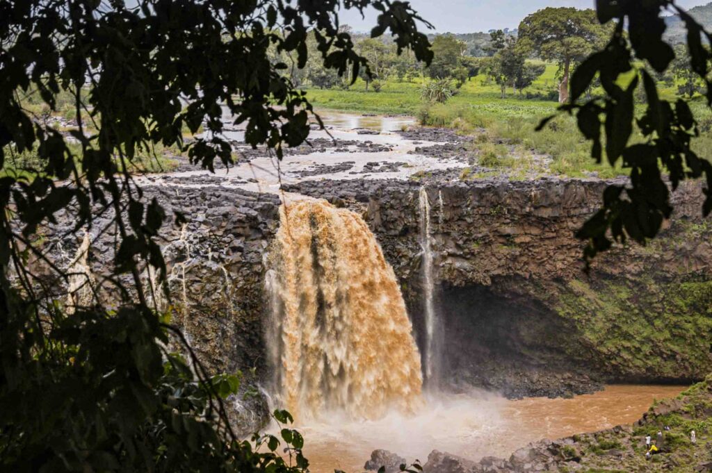
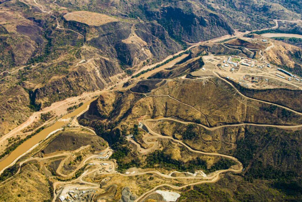
HAMROUSH The White Nile enters Egypt, 2,500 feet below its source at Jinja, providing only 15-17% of Nile waters. Ethiopia’s Blue Nile 4,600-foot fall to Khartoum is not easy to navigate, nor can you use the same boat you’d enjoy in the White Nile swamps. Yet it provides the remaining 85-83% of Egypt’s Nile waters. Running between mountains of large, black volcanic rocks, the Blue Nile’s monsoon rainwater carries lots of silt and soil from these black rocks. During annual floods, Nile mud floods Egypt’s riverbeds with mud. Most of that Nile silt will go all the way down to the Delta and the Mediterranean Sea, protecting the Nile Delta coast from pounding surf.
After Khartoum, the main Nile crosses Northern Sudan’s and Egypt’s desert northwards to the Mediterranean, with practically not a drop of rain for 2,000 kilometers. After Northern Sudan, the Nile faces many “water cataracts” with rocks, boulders and rocky islands in the midst of the river. Then, from the Aswan Dam and down to its Delta, the Nile is wide and gently sloped.
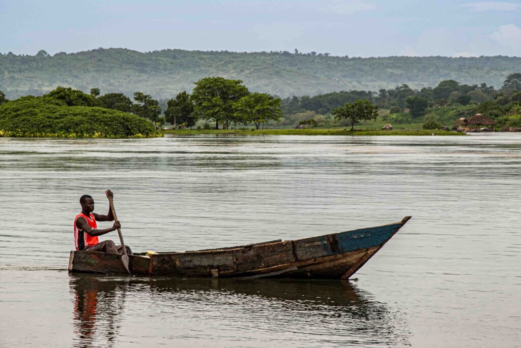
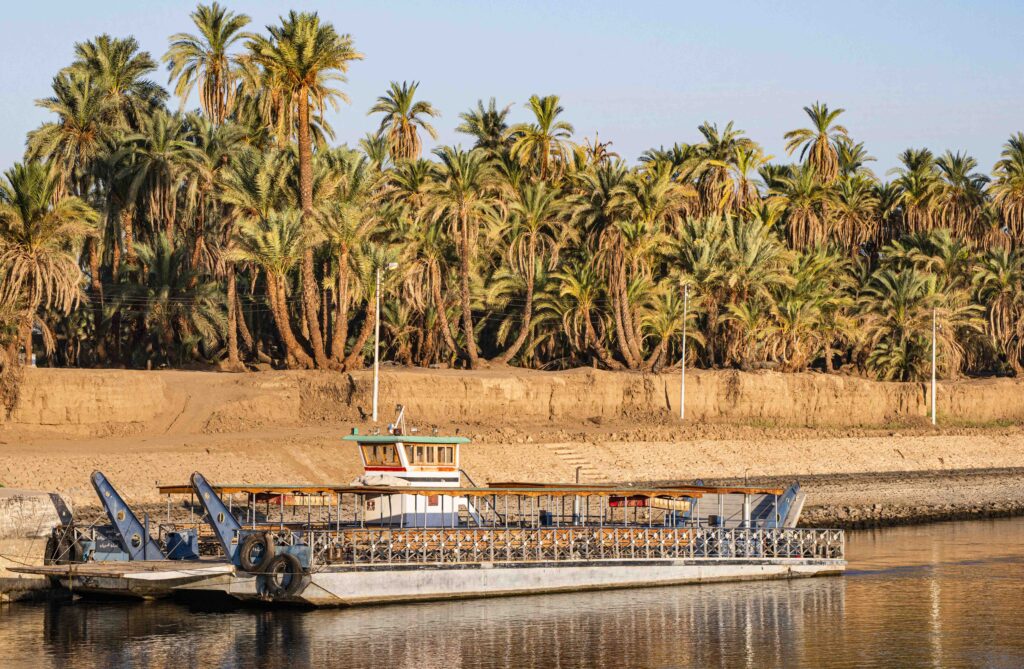
Nile Agriculture and Transport
HAMROUSH From Aswan to the Mediterranean, the riverbanks are green – not from rain, but from the agriculture civilization of ancient Egyptian farmers observing annual August-October medium-sized floods. The water level would rise a little bit to submerge the flood plain, no longer a riverbank. As the flood receded, some water remained. So, before August’s flood, the farmer irrigated, plowed to level his land and spread his seeds to allow medium flooding to irrigate his land with a few centimeters of water. As the flood eventually receded, his crops grew so that ancient Egyptian could harvest his crops.
The Nile’s annual flooding allowed this terrace irrigation to form a strong cultural civilization. Building on that, transportation on the Nile River allowed ancient Egyptian civilization to become a state with a center of control. Thus, the Nile provided agricultural production and prosperity, plus the development of a state via boat transportation and communication that could flow all the way from upper Egypt (in the South) downstream to the Nile Delta. A secondary gift was that of prevailing winds blowing down from Europe and the Mediterranean. These northern winds powered sailboats upstream against gentle currents upstream towards Sudan. So, river flooding with wind-driven communication and transportation were the two prime ingredients for the development of the very first central state along that sector of the Nile.
The fertile Nile mud has meant flood plains usually have lots of date palm trees about eight meters or seven meters high. But if it is a very high flood? Catastrophe. Disaster. There would be no dates or other agricultural production – only chaos. If it a low flood, then no agricultural production – just drought and famine. Therefore, in studying the evolution of ancient Egyptian civilization, you’ll find that building monuments and temples, economic stability and prosperity is usually associated with medium-sized floods. No high or low floods!
Kayla is a low flood. A medium-sized flood is just few centimeters above floodplain. A high flood of 1- 6 meters might reach the top of the palm trees. If so, I informally call it a “freshwater tsunami” because it would submerge everything and be catastrophic, causing great economic chaos. Thus in 1971, in the South, we constructed the High Aswan Dam to generate the second largest artificial lake in Africa, Lake Nasser. So nowadays, Egypt really can tolerate a very high flood for two years, three or four years. When floods came down from the Blue Nile monsoons, it was more than 10 meters high in Aswan in some cases. When I was a child, the water was so high that one more meter would have flooded the streets in Cairo.

NWNL: Omo v Nile River Irrigation
NWNL COMMENT on traditional Omo River agriculture in Ethiopia:
That 10-meter-high Aswan flood level was about half that of Ethiopia’s Omo River which had annual 20-meter floods – until Ethiopia built its Gibe III Dam in 2008. For 6,000 years (before the Gibe Dam), Ethiopia’s Omo tribes would await its annual 60’ floods. As those yearly floods receded, the tribes planted their sorghum in the wet riverbanks, from top to bottom, as the water dropped. When the Omo reached its low, those tribal farmers harvested the sorghum – again from top to bottom – never needing rain. While arid Ethiopia’s terrace agriculture (aka, flood-recession agriculture) is quite different from arid Egyptian floodplain agriculture (using a “shaduf” to pump Nile water to their plains), both ancient cultures depended on their rivers, in lieu of rains, to irrigate their crops.
Dam Building & Silt Retention
HAMROUSH With the very significant completion of the Aswan High Dam, Egyptians, for the very first time in 7,000 years, Egyptians were in control of the river; rather than the river being in control of their well-being. With Aswan Dam generating half of the electricity and allowing far better management of our water resources, we’ve increased agricultural production and agricultural land.
Along with Aswan High Dam, we have about nine small ones, including the beautiful 1902 Aswan Dam and its beautiful small lake. But that Aswan Dam couldn’t hold back enough water in 1927 when about 90,000 Egyptians were impacted. So they had to allow the river to pass through and run downstream to prevent complete collapse of Aswan Dam.
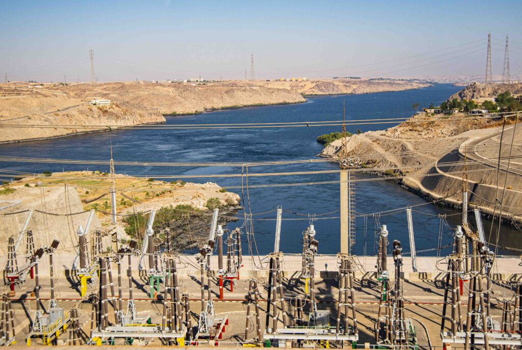
The new High Dam has advantages and disadvantages. It prevents flooded agriculture and flooded villages, such as in 1927, when we had to move people to higher locations away from the high Lake level. Its construction also incurred the tragic loss of archeological sites, requiring salvage actions. Flood retention by dams have also affected the nutrition and fishing in the Mediterranean Sea because the silt doesn’t go further down anymore. That has also affected the fertility of the Nile Valley.
Impacts of Deltaic Erosion
HAMROUSH We’ve tolerated and controlled most of the disadvantages of dams. But the last one – erosion – is difficult to mitigate. The silt used to go all the way down to the Mediterranean where it protected the Nile Delta coastline. But it is not going there anymore. Currently, there is a great deal of erosion in Egypt’s coastal range, particularly in the Delta and along the Mediterranean.
Egypt is facing the global challenges of climate change, population growth and the lack of water resources. From 1880 until now, the average global temperature increased by 1º Centigrade, (1.9 Fahrenheit). Average global sea level rise in the 20th century was 1.7 millimeters per year. Now, it’s about 3.3 millimeters per year. That’s serious.
While changes in the Delta are mainly because of sea erosion and from the Aswan High Dam and its retention of the Nile mud, there are also natural geological sub-cycles. Like any river in the world, annual Nile floods bring sediments downstream. Next year, another flood. The next year, another flood. The third year, another flood. That’s a lot of sediment! As sediments pile up and become heavy, they are compacted by gravity, decreasing the surface level of the Nile Delta. The resulting rate of subsidence has required study and future planning.
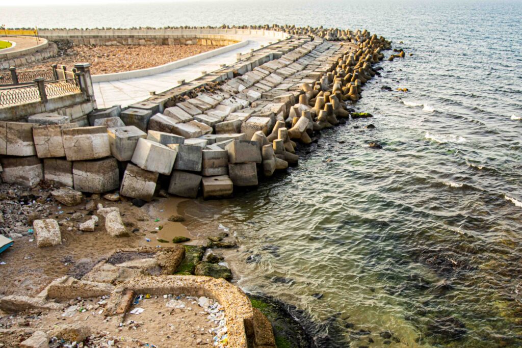
Two years ago, Professor Daniel Stanley from Smithsonian Institute indicated that the western Delta is subsiding about 6.6 millimeters/year. And every year, aggravated by 3.3 millimeters of sea level rise due to global warming. The net sea level rise is about 1 centimeter per year. In ten years, it’ll be 10 centimeters and 50 years from now, 50 centimeters higher. What’s that impact? 1,800 square kilometers will be submerged by seawater. Four million Egyptian people will be affected.
Land Conservation
HAMROUSH Egypt’s national challenge is our “human” impact on the fertile Delta land. People from rural areas are migrating to the city for better jobs. Everybody who owns land wants a high rise instead of a garden,. Cairo is expanding onto Egypt’s agricultural land. By 2008, Cairo’s population expansion expanded east and west into what was desert but are now urban centers. City planners say we have to build beltways, lots of roads, lots of water treatment plants and, and, and … Thank God we stopped a ring road around the Giza Pyramids that would have been like the Roman Coliseum. Instead, we declared it a Natural Protected Area. We can mitigate development impacts.
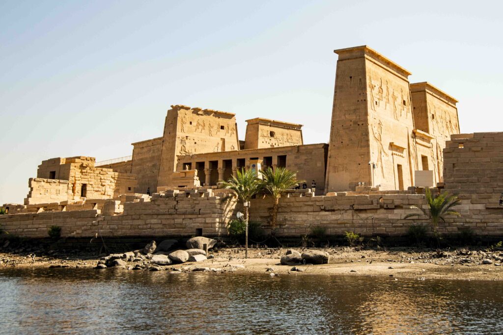
One preservation example is we moved Philae Temple and Abu Simbel Temple to prevent their being flooded by Lake Nassar when Aswan High Dam was built and necessary to save Egypt from famine, such as the one that in the mid-1980’s in Ethiopia and Sudan. During Ancient Egypt, they irrigated this Nile flood plain once a year, but now the dam provides better water management. We can irrigate the same land four times a year, allowing increased agricultural production – for increased populations.
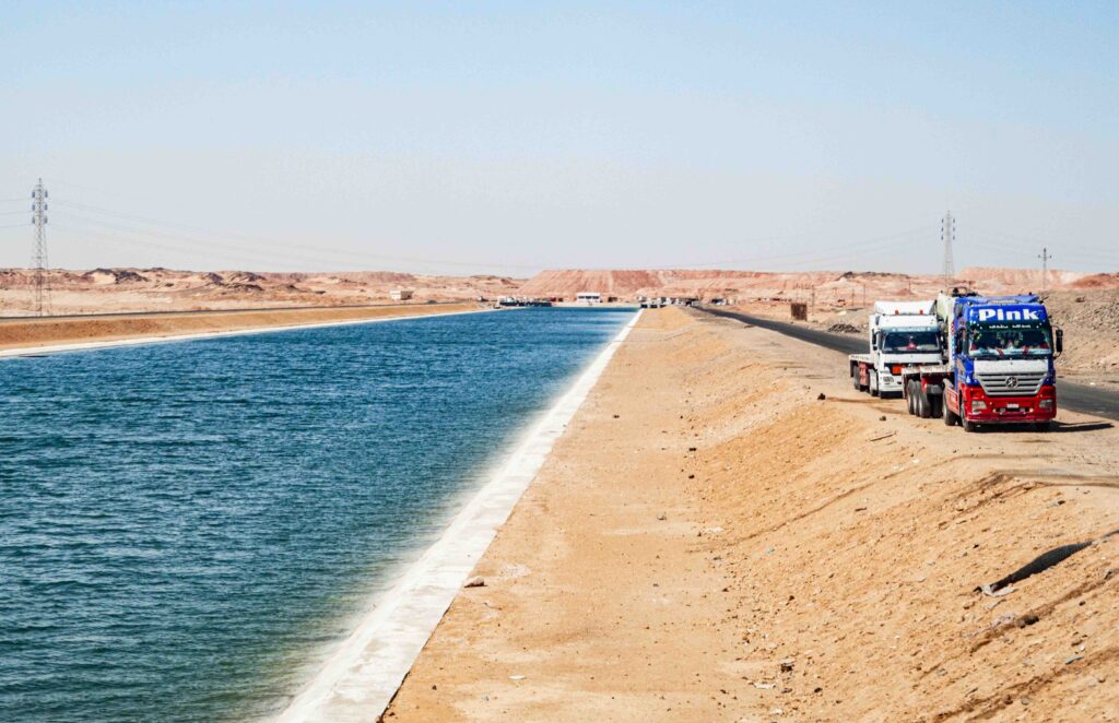
Toshka Canal & Reservoir
HAMROUSH If something like an earthquake broke the Aswan Dam, Khartoum would be submerged, God forbid. However, Egypt solved that scenario for itself. In case Lake Nasser rises to the highest level, threatening the Aswan High Dam, we have Toshka Canal. If a tsunami flood came out from the South, the canal would divert surplus water into a large depression in the desert. In 1995, 96 and 97, the lake and flood levels were very, very high. To ensure the Aswan Dam’s safety, Toshka Canal can now discharge any excess waters into three new playa lakes in the desert. In prehistoric time, the Toshka area had very heavy rain; so, several playa lakes were formed and lots of ancient civilization was developed around them.
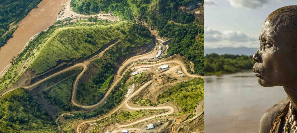
New Gerd Dam - Issues
HAMROUSH Egypt is entitled to an absolute allotment of 55.5 billion cubic meters of water – about 600 cubic meters of water, per year, per person. We agreed on that with Sudan when we constructed the Aswan High Dam and its Lake Nasser. Since Lake Nasser would submerge some of Sudan’s land, we agreed with Sudan to share this huge amount of water It’s very common to make those water agreements.
Built just on the border between Ethiopia and Sudan, the grand Ethiopian River Renaissance Dam is three times the Hoover Dam in hydro power – about 6,000 versus 2000 megawatts. Ethiopia says it constructed GERD dam to generate electricity, which is very legitimate. It’s a right, they need the electricity for development. So, they decided to construct a dam for hydropower and build a lake behind the dam – just as we did in Aswan High Dam. For us, the minute the lake is filled, no problem. It’s a win-win situation. Electricity is generated and water released. But the problem – and this is the current dispute – is how long it will take to fill the lake.
The Ethiopians want the electricity yesterday, or as fast as possible. So their scenario was, we’ll fill the lake in three years. Egyptians, on the other hand, say: “Well, it’s definitely your right to build it, but you need to consider how much water you’ll need to make sure it won’t affect our water reservoir and our share of water.” We suggested it be built on seven years, not three years.
So the issue right now is how long it will take to fill the lake. Ethiopia says it’s an issue of sovereignty so no need for talks. Egypt says Nile waters belong to all countries along its course.
Sudan won’t be too affected if only a bit or no water flows because it has the White Nile and a bit of rain. But Ethiopia is along the East African Rift System – a geologically active area. God forbid, if an earthquake occurs. I say there should have been international consultation, agreement and consensus on the design of the Aswan Dam.
NWNL - Ethiopia's Dams
NWNL COMMMENT Again I see similarities between Nile River Basin Countries. Egypt has concerns regarding GERD’s downstream impacts, just
as Kenya has had concerns that Ethiopia filling its Gibe III Dam above the Omo River would lower its Lake Turkana water levels and harm those vital fisheries. However, with studies showing that Lake Turkana water levels are known to fluctuate significantly, those concerns faded.
Equally significantly, it turns out that the main reason for Ethiopia building its Gibe III Dam was to send water stored by that dam for irrigation to nearby lands that are fertilem but arid, Then with the dam, foreign investors would pay for that stored water to grow thirsty crops of cotton and sugar. Thus, in so doing, the Gibe Dams regularly reduce the former high flows of the Omo – and tribes dependent on the Omo floods have been moved to more arid locations.
HAMROUSH If one builds a flood-prevention dam and with a reservoir, then it should continue sending the same amount of water downstream after the reservoir is filled. Fine. But it’s not fine if too much of the water is pulled out for irrigation upstream of other needed communities. So yes, there is a possibility of that happening with the Grand Renaissance Dam, but they say this GERD dam is for hydropower.
To be very, very clear very, very honest about it: all the Nile River countries should live on a win-win situation. The concern that a certain country has a bad intention is the wrong way to approach the problem. They have the right to build the dam and we have the right for the water. That’s natural; and so eventually we will end up with a peaceful solution. I assure you. I’m not going to say. “No, no, no, no. The Ethiopians are not building the dam because of the high electricity. They’re having ulterior motivations to cultivate the land and hold the water!”
When you drink lots of water, where are you going to go? To the restroom. Right? How are you going to keep the water in forever? Think about it. That’s what geology tells me. Where are you going to go? So, keep the water, keep the water. Irrigate with it. You must have a discharge for it. Correct? That’s what geologists say; and Sudan acknowledges that. But Ethiopia says all water agreements from the 1920’s until now are colonial. That’s the argument they are using: “These are agreements that were done during colonial times and the British occupation. We are not going to recognize these agreements.”
I still am very optimistic, however. I think there is plenty of water for everybody – if everybody wants to work on it. This should be the intention. It’s not a permanent solution. As the population grows, the issue continues. That’s why we should do lots of solar energy!
Posted by NWNL on October 30, 2023.
Transcription edited and condensed for clarity by Alison M. Jones.
All images © Alison M. Jones, unless otherwise noted. All rights reserved.