
Columbia River Basin
NWNL WATERSHEDS
|
NEW ESRI StoryMaps: What's On Our Shelves & NWNL Song Library & No Water No Life ESRI |
NWNL WATERSHEDS
June 2007 Columbia River Basin, Source to Sea: WA, OR, BC Canada
August 2008 Upper Columbia River Basin: British Columbia, Canada
September 2011 Toutle River Basin, Columbia River Estuary, Elwha Dam: WA
May 2014 Snake River Basin: WA, OR, ID & WY
October 2014 Spokane River Basin / Columbia R. Treaty Transboundary Conf.: WA, ID
March 2015 Snake River Basin, The Palouse: WA
May 2015 Snake River Basin: WA, OR
The Columbia River pours more water into the Pacific Ocean than any other river in North or South America, and along with its tributaries, is the dominant water system in the Pacific Northwest Region. The entire length of the river, from source to the Pacific Ocean, measures more than 1,200 miles (415 of which are in Canada). The main stem of the Columbia rises in Columbia Lake on the west slope of the Rocky Mountain Range in the East Kootenay Region of Canada (United States Geological Survey 2002).
Through its entire course, the Columbia flows through four mountain ranges (Rockies, Selkirks, Cascades, and coastal mountains) and drains 258,000 square miles of which 219,000 are in the States of Washington, Oregon, Idaho, Montana, Wyoming, Nevada, and Utah. The Columbia River Basin is bounded principally by the Rocky Mountain system on the east and north, the Cascade Range on the west, and the Great Basin on the south. The basin area includes 3,000 square miles of waterways and lakes, of which 2,500 miles are within the United States (US Army Corps of Engineers Technical Management Team 1997; United States Geological Survey 2002; Great Canadian Rivers 2003).
Most of the annual precipitation of the Columbia River Basin is concentrated in the winter months, with most of the precipitation falling as snow in mountainous areas that is stored in deep snow packs. Winter stream flows are therefore generally low, with high runoff flows occurring in the spring and early summer. This runoff pattern is typical of a seasonal mal-distribution of flow with about 60 percent of the natural runoff occurring during the months of May, June, and July. The Columbia has an average annual runoff at the mouth of about 198,000,000 acre-feet, making it second only to the Missouri-Mississippi River System in the United States in average annual runoff. The Canadian portion of the basin generally contributes about 25 percent of the runoff total (US Army Corps of Engineers Technical Management Team 1997).
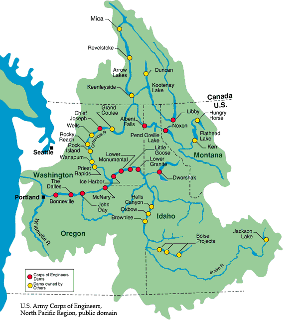
The Columbia River and its ten major tributaries (Kootenay, Okanagan, Wenatchee, Spokane, Yakima, Snake, Deschutes, Willamette, Cowlitz, and Lewis rivers) are a very complex and heavily utilized resource. As the most significant environmental forces in the Pacific Northwest, these rivers heavily influence the character and way of life of people in the region (Center for Columbia River History, 2005). The Pacific Northwest is dependent to a large extent upon the Columbia River for its power, food and fiber through irrigation, transportation through navigation, recreation, fisheries, and municipal and industrial water supply (US Army Corps of Engineers Technical Management Team 1997). In fact, the Columbia River is the most hydroelectrically developed river system in the world with over 400 dams along its length and among its tributaries (Center for Columbia River History, 2005). Power developments on the Columbia River or its tributaries are directly affected by the Columbia River Treaty signed by Canada and the United States in 1964. The treaty was signed to prevent flooding and to meet the need for additional power (Columbia Basin Trust, 2006).
Luckman and Kavanagh (2000) present examples of environmental changes in the Canadian Rockies in the context of a 1.5°C increase in mean annual temperatures over the last 100 years. During this period, increases in winter temperatures have been more than twice as large as those during spring and summer. Glacier cover has decreased by at least 25% during the 20th century and glacier fronts have receded to positions last occupied ca. 3000 years ago. These two lines of evidence suggest that the climate of the late 20th century is exceptional in the context of the last 1000 to 3000 years. Detailed studies document variable responses of vegetation to climate change that reflect species differences as well as local differences in microclimate and site conditions.
Human impacts on the environment also compound the changes due to climate warming. For example, historic photographs indicate significant changes in the type and density of forest cover due to fire suppression techniques within the National Parks during the last 70–80 years. The visual impact of these changes is far greater than the impact of changes associated with more direct tourist-related impacts. It is therefore important that monitoring programs examine vegetation changes over the entire landscape rather than focusing exclusively on supposedly climate-sensitive sites (Luckman and Kavanagh 2000).