
Salmon on Rice: The Nigiri Project & Water Use
California Megadrought
|
NEW ESRI StoryMaps: What's On Our Shelves & NWNL Song Library & No Water No Life ESRI |
California Megadrought
Carson Jeffries
University of California-Davis Center for Watershed Sciences Staff Researcher
Louise Conrad
Calif. Dept. of Water Resources, Sr. Environmental Scientist; Nigiri Project working partner
Don Hopie
Pittsburgh Post Gazette journalist;, SEC Moderator
In 2016, the annual SEJ/Society of Environmental Journalists Conference was held in California. Fortuitously, that choice allowed facilitated insightful discussions, talks and tours on the state’s ongoing ecosystem impacts of an unusually prolonged drought. The effects were affecting coastal city residents as well as the state’s Central Valley farmers and fishing industries that fill the breadbasket for communities across United States.
The location of the conference also facilitated attendance by nearby University of California scientists. Jeffrey Carsons was one of the UC staff who was very helpful showing us innovative techniques incorporating green infrastructure to help rice farmers and migratory salmon struggling to prosper despite the lack of rain filling critical waterways.
Conference attendees interested in green infrastructure and blending conservation with solutions for struggling farmers and fisheries left Sacramento by bus to see firsthand an innovative, drought-focused solution. On the bus, Don Hopie introduced Nigiri Project’s multi-pronged approach to unite farmers and fishers in fighting California’s drought challenges. Carson Jeffries and Louise Conrad then led an on-site afternoon of discussions, charts and sunshine at a local Sacramento-San Joaquin Delta farm. They clarified intriguing details of this solutions-based, innovative project. All were impressed and ready to return to their home bases to write about Nigiri’s success and inspire other similar, drought-driven challenges.
PART I –OVERVIEW ON THE BUS
OVERVIEW of the NIGIRI PROJECT
IMPACTS of GOLD & LEVEES
BUILDING ON & MANAGING A FLOOD PLAIN
GROWING RICE WITH DUCKS
GROWING RICE WITH FISH
THE COSUMNES RIVER
PEST CONTROL
THE SALMON
THE WALLACE WEIR
THE PROJECTS’ DRIVER & FUNDING
PART 2 – ON-SITE QUESTIONS & ANSWERS
Editor’s Note: This informal exchange between scientists and dozens of journalists was very informative. However brisk questioning allowed no chance for name attribution. As well, due to wind and other ambient noise, sound was often muffled. NWNL apologizes for any omitted or misconstrued words or comments.
ANNUAL CYCLES
TIMING for FLOODING FIELDS
FISH & RICE FARMERS BOTH NEED WATER
DELTA SMELT PROTECTION ACTION
GETTING SALMON TO THE OCEAN
DUPLICATING THE NIGIRI PROJECT
All images © Alison M Jones. All rights reserved.
Key Quote As climate change becomes a bigger issue, I think collaboration such as you’ll see today in the Nigiri Project will become more and more important – in California, around the country and around the world.
DON HOPIE The Nigiri Project we’re about to see is one of the most innovative collaborations between the historically competitive interests of farming and fisheries restoration. Today’s farms and fisheries compete for water, California’s most precious resource. Here in the Sacramento area, water flows down the Sacramento River; passes through the Yolo Bypass; and then flows into the Sacramento-San Joaquin Rivers Delta to finally enter the San Francisco Bay.
As climate change becomes a bigger issue, I think collaboration such as you’ll see today in the Nigiri Project will become more and more important – in California, around the country and around the world.
CARSON JEFFRIES Thanks, Don. While I am a classically trained fish biologist, that’s not what I do all the time. I work with an interdisciplinary group of people who study water tectonics, geology, geochemistry, fish, bugs, plants and such.
On most of these projects, we work together. So, I can share small nuggets of many issues if you have specific questions. My mentors are geo-morphologists who wrote The Rivers of California. While spending much of my time the last 20 years as a fish biologist, I can play both sides of the fence, from fish biology to geo-morphology.
CARSON JEFFRIES Let’s start by going back 150 years ago to figure out how California got involved in today’s water systems. Gold was discovered here 150 years ago. As hydrologic mining was used, sediment came down. That changed the hydrology of California and how water flows through this system. The US Army Corps of Engineers [hereafter, USACE] was convinced their infrastructure could keep water within the banks of the river. They would build levees high enough to funnel and manage, water within their channels so areas beyond could be incorporated for various forms of development.
The USACE claimed they’d done this in the Mississippi Basin for 75 or 100 years, and thus would go with the same plan here. But they’re still not doing it well along the Mississippi. The impact of their infrastructure here has been even worse.
For those not from California, I’ll describe our hydrology. Every year we have a rainy season and then 9 months of drought. But our 3 months of rain produce heavy precipitation, creating the potential for intense winter snow storms up in the Sierras. Then as warm days return, spring snowmelt causes intense water events in small areas. So, the Army Corps raised their levees higher and higher, yet they still couldn’t contain the big spring pulses of water rushing downstream.
Since the Mississippi River has very attenuated flood pulses, folks downstream know a flood will come in 3 weeks. But California’s flood pulses rush down quickly, so notice can be just 3 hours beforehand, causing mass chaos in California. Leland Stanford came to his inauguration as Governor of California via rowboat through a flooded Sacramento!
Such flooding isn’t sustainable for a state aspiring to be a big player in the U.S. economy – and on the global scale. So, they sought ways to control the river, control nature, and achieve what we always dreamed of doing. A newspaper editor in Colusa, a town on the Sacramento River, advocated for flood bypasses. Some areas adjacent to the river are lower than the river, so they wanted to use those chunks of land adjacent to the river as bypasses to convey flood waters.
Thus, there are two big bypasses built in California: the Sutter Bypass, further north of here, and the Yolo Bypass, where we’re going now. They were to carry the water out of their river channels and contain it within the levees to through broad, wide-open channels. We’re now crossing our downtown Sacramento River, which can convey about 80,000 cubic feet of water per second. The Yolo Bypass can convey up to 7 times that volume – about 600,000 cubic feet – per second. The Yolo Bypass has reached that capacity on several occasions since it was built.
CARSON JEFFRIES We just drove through a big flood plain that became the City of Natomas. If you plan on building and buying houses, the Natomas might not be your best bet! But because people did build there, they’ve had to manage it. That’s how we ended up with California’s flood conveyance system. We had reservoirs upstream to capture flows coming down, but they can only capture a certain amount of flow.
When they reach capacity, they need to release water, and so that’s how flood bypasses help. The Yolo Bypass was built in the early 1900s. It’s a passive bypass with a crested weir along the levee. There is a low spot in the weir that water can flow over as it rises, thus it’s deemed an “uncontrolled spill.” The Sacramento weir, just downstream up of here, is a “board weir.” Releasing those boards pulls water out into the bypass if the American River is flooding. This land on the Yolo Bypass is privately owned, but since it has a flood easement on it, the state can flood that land whenever it deems it’s appropriate to avoid flooding Sacramento and adjacent areas.
The Yolo Bypass is primarily 20,000 acres: the majority is managed for agriculture and the rest for wildlife habitat. In the wildlife refuge they manage mostly waterfowl and other wading birds. As background, a quick primer on California water history is Battling the Inland Sea: Floods, Public Policy and the Sacramento Valley [by Robert Kelly]. This book is a phenomenal read on the water history of California and how we got to this point. It might be a good read even if you’re not interested in it.
Historically, extensive floods occurred here before people and levees came in. Then, the Sacramento Valley was a big flood plain – essentially an inland sea. From an ecosystem perspective, when people moved in and started building levees 100 years ago, they essentially disconnected the river from the flood plain. So now we’re trying to reincorporate some floodplain functions on what has become a heavily managed landscape. Our consideration of restoration versus reconciliation presents an important distinction.
It’s important to study the Sacramento River levees we’re about to cross, particularly on this side. Development in Natomas was curtailed in the face of excessive flooding risks. You can see the Sacramento skyline; and that big levee, was built in the last couple years to allow Natomas to start building again. Many people think it’s a bad idea. What we have done to local hydrology over the past 100 years is not a very good record. And with the changing climate, we predict more extreme events happening.
One other story…. As we go over the Yolo Bypass, you can see an important body of water that functions as a drain. We’re now on an elevated causeway that goes over this section. Water floods out of the Sacramento River up to the trees farthest to the north, and then rolls across this landscape. This flood bypass can convey about 600,000 cubic feet per second and thus has allowed Sacramento to exist.
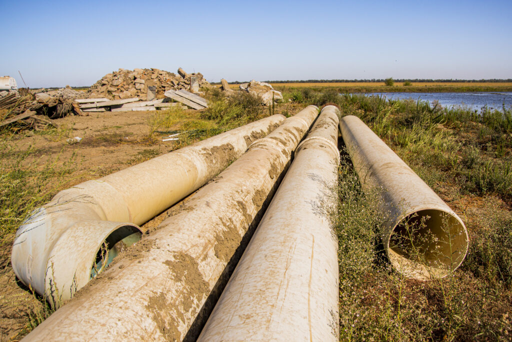
CARSON JEFFRIES Almost all rice grown in California is exported out of California. It’s a hydrated rice seeded via airplane, which is kind of cool. They do everything via airplane here. It’s a scale issue, since there are 550,000 acres of rice in the state. Harvest results change depending on drought. California has been in drought for the last few years, as most of you probably know. As it went down to about 300,000 acres, the amount of rice that was grown in the state during the drought was almost cut in half – creating a big impact in many ways.
The rice industry has realized they could get many benefits from managing their rice fields differently by including wildlife. Prior to 1990, after harvest, they burned all the fields to get rid of the stalks. Then they incorporated the ashes into the soil. However, annual burning of 550,000 acres in the Valley created terrible air quality. The Air Quality Board said, “No more burning, unless you burn less than 10% of your rice.”
So, in considering how to get rid of the rice stalks, they flooded their fields in the winter. In 1992, as they started flooding, winter waterfowl start showing up – because, historically, it had been a big inland sea below the Pacific Flyway habitat. As waterfowl showed up, creative rice farmers realized, “Wow, this is great. We can start leasing our land during the winter to duck hunters – a wealthy group of people willing to pay good money to shoot ducks during the winter.”
Since the mid-‘90s when they curtailed burning, the bird population has increased yearly. Plus, there’s been a huge increase in waterfowl, which is a big bonus for the rice industry. That’s a 2-month window, but if they manage for ducks the rest of the year, their duck population would be bigger and increase the value of their property. So. they see more ducks, more money – which is a good thing. Ultimately they’re shooting ducks, but not all, so there should be enough to come back.
CARSON JEFFRIES Bringing fish into the equation was later to the game. It’s easy to attract a duck to a rice field. But it’s a challenge to move fish from a river to a rice field, because there are levees in the way. Fish don’t do well out of the water – they haven’t developed wings yet. But in 1998, we had two big flood years – 1998 and 1999. That winter the Yolo Bypass was flooded for large periods of time.
So, Department of Water Resources biologist released 50,000 juvenile salmon on the Yolo Bypass during that flood and 50,000 fish in the adjacent. Collection traps downstream caught about 17 fish; but the fish that came across the Yolo Bypass were bigger, and that led us down this rabbit hole. When they did that, I was working on the Cosumnes River, which is an unregulated river south of Sacramento, and the only river out of the Sierras without large dams. Thus, whenever it rains, it floods. Even during these last few drought years, pretty much any rain event will flood that flood plain, as has happened historically.
CARSON JEFFRIES The Cosumnes is a small river – too small for big dams. The Nature Conservancy bought that property in the early ‘90s, when there was a big push to establish riparian corridors in the system. People were planting acorns, oats and cottonwood, but for the most part, they were unsuccessful. The Nature Conservancy was planting, planting, planting – but with very little success.
The Cosumnes had an accidental levee breach in the late ‘80s. So much sand came out that the farmers said, “Okay, I’ll just write off 5 acres off on my land because I can’t move that much sediment. Ten years later, there was a forest there. The Nature Conservancy said, “This prompts a great idea. We should let the process restore this habitat that we want.”
That led to breaching a series of levees and reincorporating the flood plain back into the Cosumnes River. To date, it’s probably the prime example of how we can reincorporate natural processes back into an ecosystem. The local species evolved with this flooding and its sediment. With the new sediment and cuttings that were in there, trees grew and birds came back. That’s when we launched our experiment on the Yolo Bypass, a very managed system.
During flood events, we went to the Cosumnes to cage fish from the flood plain and the river. Ted only got about 17 fish out of this study. Amazingly, this whole science was based on those 17 fish. They changed the trajectory of how we manage salmon in California. We then started caging fish to get statistical numbers. The fish growing on the flood plain grew at 2 times the length rate and 8 times the mass rate of the fish in the adjacent river.
That fundamentally changed our thinking on managing fish. Seattle has many of these projects copying Portugal. The same things happen when they reincorporate a flood plain to manage for fish. We can’t restore every flood plain like we did with the Cosumnes River. It is a small piece of land, but it’s the main drain for about 1 million acres on that side of the Central Valley. It drains everything almost up to Redding and through those agricultural fields. It then comes through here and goes into the Sacramento River upstream from here.
CARSON JEFFRIES One of the things from the rice industry is they have very little problem with pests. Their 10% of burning gets rid of the pests. We see herbicides, but no pesticides or insecticides in most of this water, because it’s mostly rice. They only put fertilizer on the rice fields.
However, given the mosquitos here, vector control in California is kind of the big trump card during the summer and during the winter. Our fish come on February 1st, and we try and have them off the flood plain by March 15th. So, we only use a six-week window during the wintertime for flooding this land for fish.
CARSON JEFFRIES Salmon in California, different than the Northwest, are all the “ocean type” – meaning that adults come in in the fall. We have 4 runs of salmon, but the majority come in the fall and spawn in September/October. Then the juveniles come out of the ground in January or February, and head to the ocean, to return between 3 to 5 years later. So their time in the fresh water is a very short period, unlike the spring salmon farther north that spend summers in the rivers, and then go back out in spring or winter, riding that wave down.
Because it’s so warm in California, we don’t have enough cold water in the rivers to provide habitat for juveniles. Historically there were more spring-run fish that came in as adults; spent that summer in the fresh water; and then spawned in the fall. But with the cutoff by dams, that didn’t happen anymore.
What had allowed those fish to be here was that they could swim high enough in the watershed to get into the Sierras where they’d be cool enough to survive. There were warm summers in California, but most of those fish were the ocean type that left their first year. The fish coming from spawning grounds higher up in the watershed during winter and spring runoffs are about 1” long – really, just functional particles.
They don’t decide where they’re going during a flood event – so they’re washed out onto these habitats we’ve provided; and that’s what happened historically. That is the process we’re now trying to recreate with a flood depth of 12 to 18.” Since it’s not a lot of water, we don’t need large infrastructure to manage it.
CARSON JEFFRIES We’re now at the Wallace Weir which drains a million acres in the wintertime. The water comes down the Bypass and attracts a lot of fish; but they have no way back into the river. So, this is a dead-end path for them. In 2013-14, about 600 winter-run salmon came up this canal and about half of the population died in that basin. It was bad. So, now they’re building a new fish collection facility at this weir so they can collect those fish before they go up above. Juvenile winter-run salmon also benefit from the flood plain waters coming out. So, one long-term goal is to increase the frequency of flooding this area.
The next big phase in this Wallace Weir infrastructure complex is to put an operational weir in Fremont. I’ve described a passive weir as a low spot in the levee the releases water. Our idea now is to lower that weir and install an operational gate to let water out during smaller flood events. Thus, when you release the top of those flood flows, but you can also send little flow events that would otherwise be channelized down the river through the bypass and onto the flood plain.
California’s hatchery population is kind of a mess. Particularly during drought, they truck most of the hatchery fish into the Delta, and so we’ve lost the integrity of our salmon species. The genetic integrity of the Central Valley fishery stocks is not very good. There’s good evidence that very little wild reproduction is happening in this system. We are almost completely reliant on hatchery stocks – due to this system being stuck between two levees. Regarding that “string of pearls” I mentioned, without the Bypass, there are no pearls. It’s a string of death – and not a good place.
CARSON JEFFRIES This project has had several sources of funding. The State is interested in the stories of these flood plains being useful; and it has a vested interest, because they’re managing that fish population. The Bureau of Reclamation also has a vested interest, because they are the big diverter of water to Southern California.
Interestingly, other places with a Mediterranean climate like this have very similar processes they manage within their flood plains. For instance, Australia has many in the Billabongs. Flood plains are important for fish that have very seasonal systems: a growing season and a non-growing season. A place like this, despite being on a heavily managed area, has a specific growing season and an essential period of not managing the land as it cycles back to its wildlife ecosystem function.
Editor’s Note: We’re unable to name those speaking from the crowd of journalists, so they are each noted as JOURNALIST. When attribution of the two speakers was unclear, we indicated: CARSON or LOUISE CONRAD.
CARSON JEFFRIES Welcome to this very productive environment of river and its flooding. I like to say we have a so-called “solar panel” in this levee-ed channel, since this flood plain essentially becomes a big solar panel as water spreads out, creating primary and secondary productivity.
LOUISE CONRAD As Carson said, I work for the California Department of Water Resources, an inter-agency group of folks in an ecological program that has monitored and researched the San Francisco Bay Estuary for 40 years. Over the last 15 years or so, there’s been increased understanding of how important flood plains are to the ecosystem and why we don’t have them anymore. They are a hugely productive and without them we really can’t grow fish.
So, here there are farms. In the last 5 years, we’ve learned that agricultural land is valuable even when not used for crops, since it then can be used for fish and birds. One of the most exciting parts of my job now is to interface one-on-one with landowners who want to learn how their land can be useful for natural resources like fish – not just for agriculture.
CARSON or LOUISE CONRAD Our yearly cycle begins in July as we plan for the next year, using adaptive management. We look at the results from previous years and think what they mean for the Department of Water Resources. We want to know more and then design a study for the next year, based on what we’ve learned.
After 5 years, we’ve scaled up. This is no longer just a study. In September and October, we’ll refine our plans, look preliminarily at data and talk with landowners about what to do before the rain comes. If we have dry conditions, our strategy will focus on what we can learn by having managed inundation.
At this location, we have a whole battery of 2-acre fields that can each be flooded with our pump system. We’ve done many types of studies; and at the beginning, nobody was really interested. But now, after 5 years of work, a few landowners are interested in having their land by part of this study.
Many of the rice farmers were upset that we were infringing on the normal cycle of rice and perhaps taking away potential productivity. But they changed their position from “You guys are crazy” and “There’s no way this will work” to “Hey, can I get on board?”
There’s also been a shift in how people think about the potential it has for them. Ultimately farmers are businesspeople; and so, they’re starting to see potential through mitigation money and other revenue streams.
CARSON or LOUISE CONRAD The farmer’s cycle begins in May as they prep the fields and then drop the seed from the air and level them out. After the rice gets going and is more competitive, they lower the water level a little bit and the rice grows up during the summer. From June to September, the fields are flooded for growing rice all summer.
At the end of September, October, they start emptying those fields. When dry enough, they’ll harvest the rice; and flood up again by the end of October for duck-hunting season and waterfowl habitat. We add fish from mid-January to mid-March, depending on the water levels. From March to end of April or May, according to year’s water levels, we prep for farming.
JOURNALIST How many acres are used in the program and what percent of the fishery can it sustain? Are you mostly a research boutique, or a bigger entity?
CARSON or LOUISE CONRAD We’ve scaled up to include farms throughout the Valley and on the Bypass. We also hope to scale up to capture and retain large flood events. So, we’re transitioning from proof-of-concept on a small scale to implementation on a larger scale. Results from our small pilot settings will direct change on a larger scale.
JOURNALIST How much acreage do you work with now and how much do you need to really make a population-scale difference?
JOURNALIST Regarding biological opinions and such, the Department of Water Resources and the Bureau of Reclamation are required to restore 17,000 acres of floodplain habitat for the purpose of salmon restoration. This project works on about 1,000 acres.
CARSON or LOUISE CONRAD We started with 5 acres in 2012 when this was literally a mud puddle. Now, in our 5th year, we have good cooperation, interest and engagement from the landowners and much more acreage. But getting all the folks in the Bypass to be engaged is what will make the difference.
JOURNALIST 1,000 acres are now involved. How do you separate what you’re doing from the other 16,000 acres?
CARSON or LOUISE CONRAD When the Yolo Bypass floods, the whole area is available to salmon. Now there’s much research on the Bypass, a perennial canal, and the tow drain that’s always got water because it’s an agricultural drainage system.
The Department of Water Resources has had fishery traps, food and web monitoring going on since 1988. That’s the foundation for some of our research that shows that when the bypass floods there’s access to the flood plain. They grow a lot better than if they’re in the river.
When it’s flooded, it’s all good. One problem is that these rice fields are laser-levelled to grade as fast as possible. So, we’ve worked on increasing small flood events that have the potential. Historically, they probably had a lot of eco-system benefit and increased the amount of time that water spent here before it drained off. Right now, there’s just rice infrastructure.
From the river to flood plains, the water is all the same. On the flood plain, water settles out a bit and gets a bit warm. After 10 to 14 days of it warming and settling, we see zooplankton – water’s food web. We get a productivity on the field that we can’t get in a river channel – and it takes water out of the river channel.
This summer we’ve been saying, “Okay, now we know that this is good habitat for the fish; but how do we make it work on a bigger scale? One option is renting the land.
We’re now looking at using this model for waterfowl. Farmers are saying, “For $3 an acre, or whatever, I’ll keep watering it during the right time for the waterfowl.” Landowners are busy, but they deal with our questions and our requests. Going forward, they’ll know what to do and that we’re available for them. We’ll need to manage for salmon during the flood season. We’ll provide the science to show that this is a potential avenue for going forward.
JOURNALIST When you drain the field, do the fish instinctively go to the drain? Is there any retention or loss of fish as water levels drop and hold fish behind in clogged dirt?
CARSON or LOUISE CONRAD That’s a great question. It’s variable. We’ve gone through different management of those fields. How do we drain them? What’s the best way to get the fish out? How do they leave on their own?
We’ve done studies and we now know how to get them off the field and when it’s time to go help them out. If we let them go on their own, they just trickle out as they reach a certain point where the temperature is starting to warm up and they’re physiologically ready to smolt and get out.
Most of the fish we see leaving are getting ready to go to the ocean. They’re starting to lose their scales and getting silvery. They’re also get very fat and chunky as they get ready to go the ocean. Our goal is to provide a mosaic of habitats to allow fish to stay in them as they work their way downstream
There are not enough of those habitats. We also must think of all the things that they eat that will also die. We put 50,000 fish on these fields – but they’re all small. I just got a call last week, saying, “I think it’s cool.” There is a regime shift happening. It’s suddenly cool to be a part of Project Nigiri.
JOURNALIST In some ways you’re extending the residents’ time later in the year for the salmon. I’m curious. Does that hold the birds longer?
CARSON JEFFRIES That is a great question. Three years ago, we were running our experiment in the middle of a drought. During a normal March out here, most of these fields are flooded. But there was so little water that we had the only mud puddle on the Yolo Bypass and it was impressive how we attracted the birds. When there is water spread out, even a normal flood event or a normal March, they’re not concentrated like they were on that “mud puddle” created on the Bypass.
From a management perspective, we realized that if it’s warming up, but nothing is wet, it’s a good idea to get those fish out of there – especially if it’s not the right time of year for them to be there. So, there is a big window that we’re following as far as what the conditions can do. If it’s too wet for the farmers, then it’s good for fish. During these experiments at non-flooding times, we use water as it comes down. During the wintertime there’s very little water coming off, so we just borrow water as it moves down.
The goal though, is for natural flood events being retained – and we’re not losing a lot of water during that time of year. So, the state board is not that interested or concerned, it seems – and it doesn’t seem there’s any potential for water rights claims. They’ve given us their blessing on everything thus far.
I am interested in sampling the density of fish that arrive at the fields on their own when we have natural floods – and let’s hope we have more of them! That would be before we get and put hatchery fish there ourselves. I don’t have results yet because we haven’t had enough natural floods giving fish the opportunity to get to the fields on their own.
We all agree that we’re using hatchery fish right now to understand the processes and to help guide management in advocating for wildlife. Hatchery fish give us a sample size where we get some data that we can say this is how the fish respond. But yes, the goal is that they’re not part of the picture in the long-term. Did you talk about revisions to [inaudible] and how …
LOUISE CONRAD So, Carson has discussed the connection north of here where Sacramento, when at high water, is connected to the Yolo Bypass. It’s a 2-mile stretch that is just a pile of dirt. It’s not operable since there are no gates or anything. When the Sacramento River rises over 33.5 feet, then the water starts coming into the Yolo Bypass – not before. So, the Department of Water Resources and the Bureau of Reclamation need to change that. They need to modify that weir so that there are more free points and longer lasting flooding in the Bypass. That alone will increase opportunities for fish to come into the Bypass.
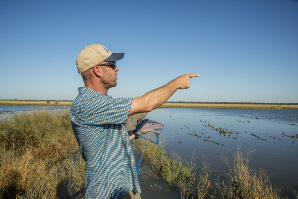
LOUISE CONRAD Rice fields aren’t designed to drain. If you’re a farmer you want to be able to drain your field. But we’re learning that that’s dissonant with what the fish need. The fish need to have the water held on the fields for a little bit longer than it takes a natural rice field to drain, because once you spread that water out, it takes time to cook up the food web. So, that’s one reason that we need to work with the landowners.
We can’t just modify Fremont Weir and have the water come onto the Yolo Bypass more often. We need to work with the landowners on holding the water longer than it would normally take. Farmers “laser level” their rice fields so they drain well; but in winter we want to hold back that drainage. That’s a big issue that we’ve learned and we’re hoping to work out together with them.
The model for land practice here would say, “Okay, the water’s coming down. We have a storm system coming in and know we’re going to flood. It’s time for farmers A, B, C and D to put boards in their fields at their outlets and keep the flood water – please!”
More water may be needed, as Carson just noted, to keep that water flow going. Yet, the idea is that we hold back the flood. Historically, flood water would stay a lot longer on the land. We don’t factor that in as much in the current flood plain.
JOURNALIST How long does water stay on a field when drained for rice?
CARSON or LOUISE CONRAD About a week.
JOURNALIST Can you allow 10 days to two weeks?
CARSON or LOUISE CONRAD We want 2-3 weeks, depending on the time of year.
JOURNALIST After salmon are reared, how are they tracked and monitored?
CARSON or LOUISE CONRAD There are many different options. Before they’re released, all fish receive a code or bar tag that’s a very tiny piece of fire you can see with your naked eye. Each of those pieces of wire has a little batch code on it. About 25% of all California hatchery fish – and even more up in the Northwest – are tagged this way. With a sort-of little sewing machine, they insert that tag into the fish’s nose tissue and it stays in the fish for life.
When that fish is caught in an ocean fishery or found as a carcass on spawning grounds, that tag can be recovered and looked at under a microscope to reveal its batch code that says, “That fish came from Feather River hatchery, Nag’s Ranch hatchery, or wherever.
There’s an additional, more expensive way to do it with a subset of fish. An inserted acoustic tag emits a sound that gets picked up with receivers carefully placed along their migration route. They don’t last for the lifetime of a fish – but we call them “listening stations.” They let us know precisely when that fish was tagged and its whole history.
JOURNALIST I understand that historically many rice farms dealt with the chaff by either burning it or flooding the fields to enable decomposition. That seemed to be a win-win. Could farmers here do that?
CARSON or LOUISE CONRAD Basically, it’s harder to get fish from a river to a rice field than it is to get a bird to land in it. So, we’re limited by the number of rice fields to which we have reasonable access from river to rice field. We’re essentially following on their heels.
Our efforts are mimicking a natural process that existed here historically – essentially in marsh wetland throughout the Central Valley. When we flood up in the winter-fall harvest, we mimic the historic wetland that was here. Birds flying over recognize it as the habitat they should be in. We’re essentially trying to do the same thing for the fish – but providing the access is the complicated part.
JOURNALIST My understanding is that there was a Delta smelt protection effort around the Yolo Bypass this summer; and it seemed that there was some salmon activity as well. Were you part of that experiment?
LOUISE CONRAD Yes. I’m with the Department of Water Resources, which was one of the lead agencies on that. We saw potential signs for that before the rains came. We saw we could round water through the tow drain in the Yolo Bypass to seed the food web downstream in the lower Sacramento River.
That action was a huge cooperative effort with many different landowners who coordinated the release of their agricultural drainage water. Instead of doing it at any old time that worked for them individually, they agreed, “Let’s do it together at this time.” That created a stronger pulse to send water out of the Yolo Bypass. In normal situations, because of the hydrology and its negative flow against the tides, when you do all the math, more water stayed in than going out. We needed it to leave so that it could seed that lower food web.
JOURNALIST So there was no additional release along the river?
LOUISE CONRAD There was a little bit of water, but not much. The whole idea was that it would be a low-cost way to do something positive for the fisheries in the Estuary that are suffering, largely from lack of food. We saw a great response of chlorophyll, an indicator of the amount of phytoplankton there and the base of the food web. There was a huge response. It took almost a month after the initial pulse of water for us to see it, but it did happen. That was exciting – yeah!
JOURNALIST Do the nutrients that are grown in those 2 or 3 weeks, replace the nutrient in the soil from burned debris?
LOUISE CONRAD Yes. They do replace the breakdown of the straw. They’ve found there hasn’t been a loss of productivity from the change in burning.
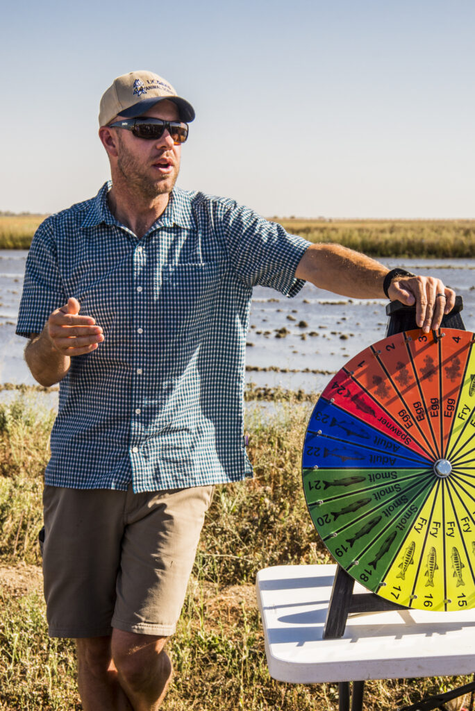
CARSON JEFFRIES Before we go, look at this “Wheel of Misfortune” we just built. The kids can give you a spin on it. Basically, it represents the life cycle of salmon: the spawners, the eggs, the smelts, and the adults in the ocean. It shows there are lots of ways to die as a salmon – but there’s only one way to survive. It is one of the things we do with kids.
This numbers game is heavily advantageous for the adult in that very, very small numbers survive and if can make big jumps in the survival rate, you’re going to live on as an adult.
JOURNALIST Are the selection numbers on that wheel statistically represented?
CARSON or LOUISE CONRAD No. We can’t project a thousand directions here! We could never find a board big enough.
This evolution of the California salmon is based on our Mediterranean climate, where they’re not here during the warm summer months. There are exemptions – the winter run, the spring run. But most of our fish follow that life history. So, our changing climate is not a terrible situation for a salmon.
JOURNALIST Do you know what their upper limit is regarding temperatures?
CARSON or LOUISE CONRAD Egg survival is complicated because it depends where they’re at in reproduction. Juvenile salmon are dependent on the amount of food available. They’re a cold-blooded creature: the warmer it is, the higher their metabolism. So, if you can offset that with more food, then you can raise the survivable temperature.
We’ve also learned that in temperatures we’d historically thought wouldn’t have been survivable for salmon, they are just thriving in because there is so much food that can offset that metabolism.
CARSON JEFFRIES Let’s walk over to the trees and tow drain that connects to the Delta. We’ve tagged fish out here; released them; and then, in just 8 days, seen them at the Golden Gate. These days, they’ve hit that point where they’re smolts and ready to go to the ocean. They’ve made that physiological transition from being a fry and are ready to go to the ocean. Big fish going to the ocean is good. There’s a direct correlation between the size of fish that leave for the ocean and their likelihood of returning as adults.
JOURNALIST Is it practical to re-duplicate your process in most, or all, of the rice fields in California?
CARSON or LOUISE CONRAD It’s not. One prerequisite is that there must be adjacency to the river. And there’s the issue of the density with which we can grow fish.. Because there’s so much food, there’s a competition for space. When your fish are still small, is you can fit a lot of fish out here. We’re putting 6,000 to 8,000 fish in a field this size and we’re not seeing any difference in their growth rate versus fish in smaller densities. We haven’t reached a threshold where we’re seeing a density dependent problem. When you scale that up, even in the 20,000 acres of the Yolo Bypass, we’re not even touching the populations we see coming down. So, the density potential is high.
JOURNALIST Do you have any survival threats, such as being vulnerable to predation?
CARSON or LOUISE CONRAD During the winter, the wind normally keeps the water mixed up and so it’s really turbid. During normal conditions, there’s little predation as long when water is spread over the landscape. But, when we are the only wet spots on the landscape, we have intense avian predation. The big predators include a couple species of egrets, the herons and the cormorants.
JOURNALIST In the winter is there other food for the birds?
CARSON or LOUISE CONRAD Yes, interestingly, the birds normally eat the rice; then the waste grain; and finally, the zooplankton in the water.
———————————
JOURNALISTS’ HUMOR To honor journalists’ natural curiosity and need for conviction, below is a random conversation caught on the end of the tape! Enjoy!
JOURNALIST Is that a caterpillar?
JOURNALIST It’s a “fuzzy wuzzy.”
JOURNALIST What is it going to turn into?
JOURNALIST I don’t know.
JOURNALIST A snake.
JOURNALIST A butterfly.
JOURNALIST If you say it with conviction, I’ll believe you.
Posted by NWNL on November 30, 2025.
Transcription edited and condensed for clarity by Alison M. Jones.
All images © Alison M. Jones, unless otherwise noted. All rights reserved.