
Atchafalaya Basin
Mississippi River Basin
|
NEW ESRI StoryMaps: What's On Our Shelves & NWNL Song Library & No Water No Life ESRI |
Mississippi River Basin
Bryan P. Piazza, Ph. D.
The Nature Conservancy, Director of Fresh Water and Marine Science
Alison M. Jones
NWNL Director & Photographer
All images © Alison M. Jones. All rights reserved.
NWNL How did you end up in Baton Rouge with The Nature Conservancy
BRYAN PIAZZA My background that got me here to Baton Rouge is that I am originally from Milwaukee, Wisconsin. I went to college there and always loved to hunt ducks and be in wetlands and marshes. So I said, “I’m going to drive down to Louisiana and see how, where the real duck hunting is.” During my Masters degree in Wildlife Science at LSU, I worked and lived in the Atchafalaya Delta for a couple of years, researching wading birds, herring, egrets and ibises, their nesting habits and the wading-bird rookeries.
I worked as an assistant manager for the Caernarvon Freshwater Diversion Project south of New Orleans. Then that was our largest reintroduction of Mississippi River water back into the estuaries, helping the land loss here in a coastal zone that is mainly driven by subsidence and lack of sediment input from the river.
When I was doing management, there were questions about evaluating environmental benefits of restoration projects. When the U. S. Army Corps of Engineers or anybody builds a restoration project, a bridge or anything, they work off of a cost-benefit ratio. Well those costs are easy to come up with. We know how much a yard of concrete costs and how much rebar costs. But I felt like we had no idea of the environmental value of restoration. So I went back to LSU as a full-time researcher to answer this question on evaluating restoration methods used in Louisiana for environmental benefits, specifically fisheries. And I focused a lot on oyster reforestation.
While doing that, I began a research program below the Caernarvon Freshwater Diversion Project where I had worked as a manager. I understood the policy side, so now I got into the science; and this became my dissertation project. Well, then enter The Nature Conservancy. They were looking for somebody familiar with the Atchafalaya Basin, riverine processes, interactions with the coastal zone and oyster reforestation. So I was a pretty good fit for the position that I have now.
If you’re a freshwater ecologist or a marine ecologist in Louisiana, it’s pretty hard to do just one or the other. I’ve always spanned into the estuaries, so I’m actually a coastal and a river ecologist.
NWNL With that background, you certainly are well qualified to clearly define the Atchafalaya Basin.
BRYAN PIAZZA There are a number of different definitions of the Atchafalaya basin, depending on whom you’re talking to. If you talk to a geologist, a geologist would give you one definition. If you talk to an engineer from the U. S. Army Corps of Engineers, they would give you another one. And if you talk to a craw-fisherman, he might give you another one.

BRYAN PIAZZA In The Nature Conservancy, we define the Atchafalaya Basin at three different levels. The first level is the “Historical Atchafalaya Basin,” which starts at the confluence of the Mississippi, Atchafalaya and Red Rivers at the Old River Control Structure, near Simmesport, Louisiana. The historic boundaries extend on the west side along the Bayou Teche ridge, and on the east side along the old Mississippi River down into the Bayou LaFourche ridge near the coast. Our historical definition extends out into the 6-foot deep Atchafalaya Bay (that existed prior to the newly built-up Atchafalaya Delta) and then out to the Gulf of Mexico. And to further confuse things, The Bayou Teche used to be a distributary of the Mississippi River.
The second-level definition that we speak about is the “Atchafalaya Basin Floodway.” This is what most people think about when they talk about being in the Atchafalaya or cross the basin on Interstate 10. It is the area between the east and west Atchafalaya Flood Protection Levees which are 15 to 30 miles apart, depending on where you are. This area extends south as a system of floodways from the Old River Control Structure all the way down to Morgan City. It includes the east Atchafalaya Basin Floodway, the Morganza Floodway, and the Atchafalaya Basin floodway system. That’s what most people talk about.
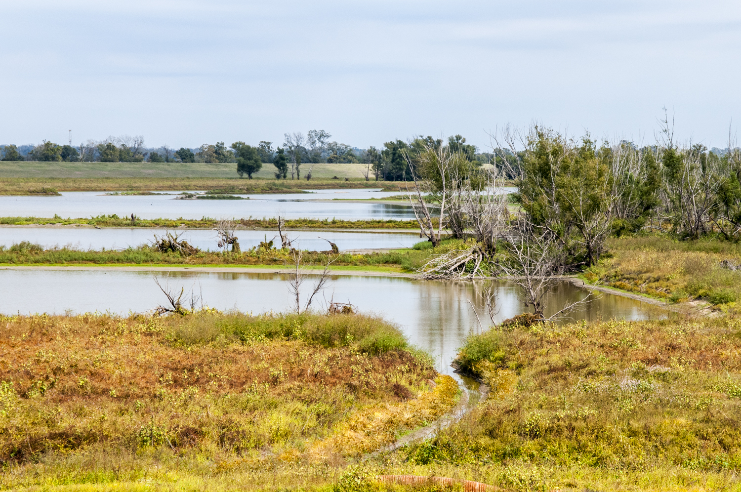
BRYAN PIAZZA The third-level definition of the Atchafalaya Basin at The Nature Conservancy is what we call the “Modern Atchafalaya Basin. That is the “Atchafalaya Basin Floodway” down to Morgan City, plus the Atchafalaya Delta, as well as East and West Cote Blanche Bay, Vermilion Bay, and others now heavily influenced by the Atchafalaya River, although not until halfway through the 1900s. So if you talk about the basin to a craw-fisherman or somebody local, they’ll define it as the floodway. But The Nature Conservancy describes it at three different levels.
NWNL What is your current focus regarding the Atchafalaya Basin system?
BRYAN PIAZZA The last two years I’ve done an interdisciplinary science review of everything written for the Atchafalaya Basin system: all the science, geology, ecology, forestry, fisheries, and the oil spill. This study would be out already if we hadn’t had the oil spill and flood. At the moment we are calling it the State of the Basin Report. It has been peer reviewed already, and I’m trying to finish it now.
NWNL Rebecca Wodder, who is with American Rivers, said in 2006, “The first line of defense against floods is healthy rivers and wetlands which act like basins and sponges, soaking up floodwaters and then releasing them gradually after a storm has passed.” How have natural processes in the Historic Atchafalaya Basin changed in the Modern Atchafalaya Basin, given the effects of climate change, infrastructure and other impacts?
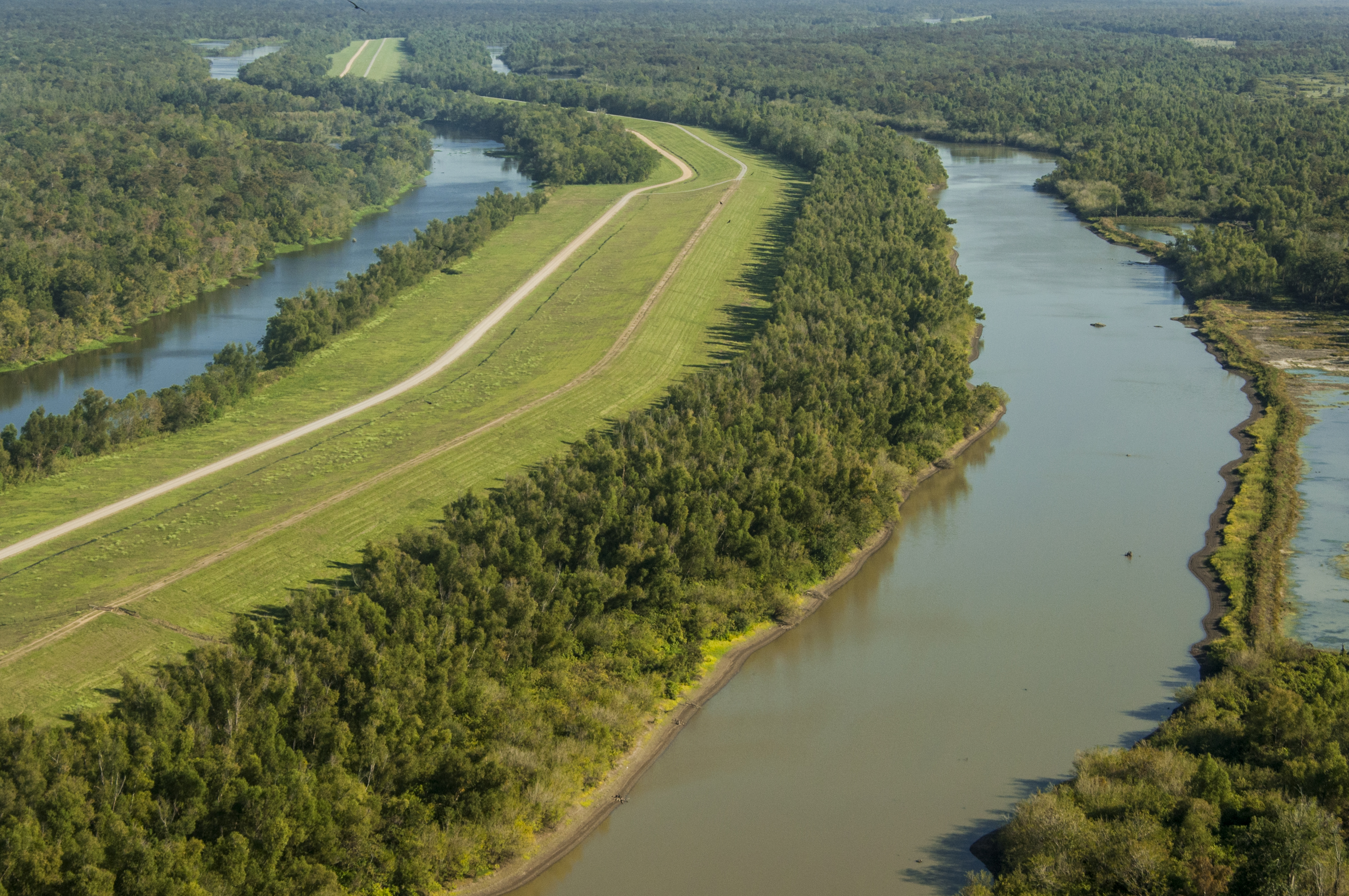
BRYAN PIAZZA In a nutshell, in the Atchafalaya Basin today has a problem of water management. The problem basically is there’s too much water for too long. The effect of today’s depth and duration of flooding crosses scientific disciplines. It affects our forests. It affects our fisheries. It affects nitrogen levels. It has multiple effects. There are two scales of infrastructure causing problems. The first is what we think may be a problem with current management structure at the Old River Control Structure.

BRYAN PIAZZA The second problem is a smaller-scale issue. When water gets into the basin and into the swamp forest, it can’t get out. That problem is exacerbated by the infrastructure of canals put in for oil and gas extraction. The Atchafalaya Basin is a coastal delta system, from which lot of oil and gas resources have been extracted for use by our country and other countries. It is a very important mineral extraction location.
But here’s the problem…. when you dig a canal, you have to put the dirt somewhere, right? So the soil is stacked upon the side canals, creating “spoil banks”. If a canal and its associated spoil banks are running in an east-west direction, water that normally runs north-south in this basin cannot easily go around or over the top of those spoil banks. What you end up with is an impoundment.
The second problem is that in some places these canals and levees actually can make water move in the opposite direction than it’s supposed to move. So water in some canals can be transported to the north, while water from the river is trying to move south, because that’s the way it flows.
The other problem occurs when canals are directly linked to the Atchafalaya River and the sediment source in the Atchafalaya River. When a canal goes into a cypress swamp, you end up with basically a pipe that pumps sediment and freshwater directly into a swamp. Now swamps are supposed to get a little bit of sediment. They need it to keep up with subsidence; and they need sediment nutrients to help the trees grow. They need this gradual build-up so that there’s some drying time that allows new plants, new cypress trees and new tupelo trees to come up. But when canals pipe sediment into an area, we see sediment rates that can be up to tens of times what these areas would receive if they were merely over-topped naturally.
Areas of the swamp forest also can be flooded from two different directions – from the north and also the south. When sediment piles into them from two different directions, it accelerates the conversion of cypress swamp forest into bottomland hardwood tree communities. Now the natural trajectory in the Atchafalaya Basin is that open water turns delta willow into either bottomland hardwood forest or over time cypress forest, depending on the elevation of the land. But we are artificially accelerating that process due to the impacts of the canals.
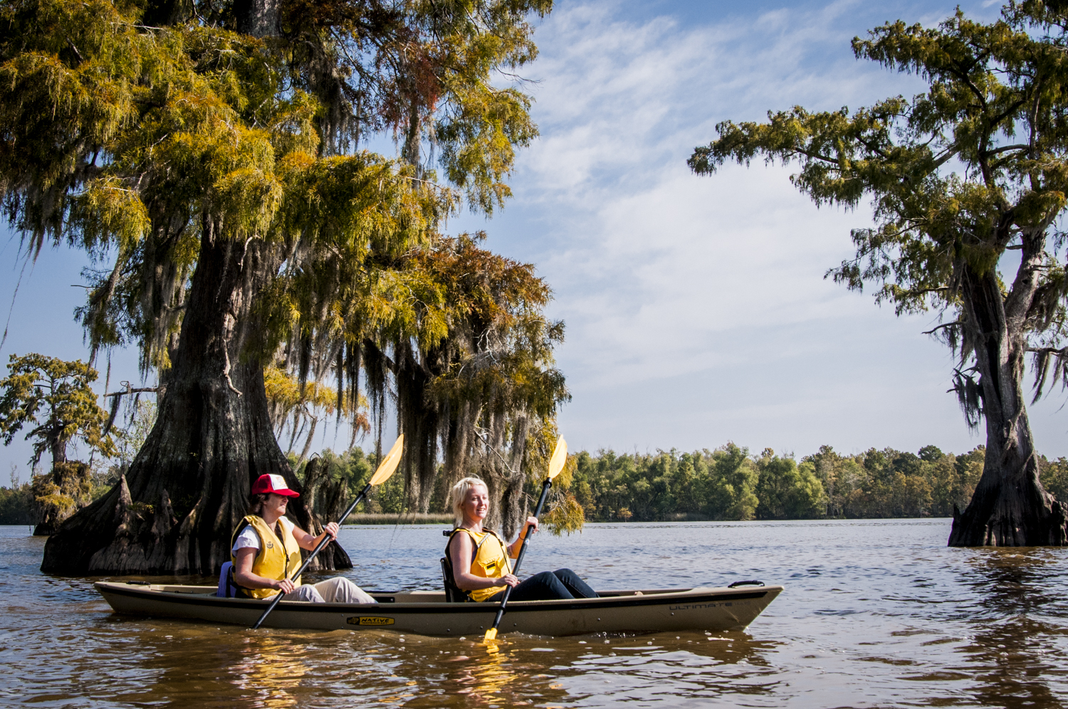
Now a bottomland hardwood forest is not bad. It’s great bear habitat, great wildlife habitat, and great bird habitat. But the issue, as with a lot of environmental issues, is what do we want to see? I don’t have the answers. But these are questions that we need to ask. The question I always ask, is can you imagine a Louisiana without cypress trees? Firstly, from a cultural perspective, that’s pretty important. The Atchafalaya Basin is the heart and soul of our Cajun culture. It literally is in the middle of our Cajun country. It is the heart of it.
The second question is whether we are willing to accept the loss of the largest stand of coastal cypress forest left in North America – right here in the Atchafalaya Basin. We have about a hundred thousand acres of cypress-tupelo swamp. We consider this a coastal system and so this is a coastal cypress. Coastal cypress forests are incredibly important, but they are under a lot of threats and we find them disappearing across the gulf coasts. We have one of the largest blocks left.
So we need to think about that and ask whether such as loss is something we’re willing to accept. Now if it is, that’s an answer. And if it isn’t, we can’t stop time, but we can start looking at ways to slow this artificial acceleration. And infrastructure is a big factor – it not only converts cypress forests into a bottomland hardwood forest community, but it also drives the water-quality problems that we have associated with the extended flooding. And that threatens the extended ability of our cypress forest.
That’s a complicated answer, but this is an extremely complicated place. In fact, the most complicated place I’ve ever worked. So there are many factors to consider. That’s why my answer may be a little long, but I had to talk about that before talking about sea-water-level rise.


NWNL In your conversation about oil and gas canals increasing sediment, you didn’t mention higher sediment loads coming down from the Mississippi River.
BRYAN PIAZZA The question of sediment coming down the river is an interesting one. We have to step back a little bit in history to understand sediment history in this system. The Atchafalaya Basin has been in this intimate relationship with the Mississippi River for the last 9,000 years. Parts of the Atchafalaya Basin were affected by two large-scale, delta-building events prior to 9,000 years ago. The places where we see cypress forests in the southeastern portion of the Atchafalaya Basin are our oldest historical footprints.
Those were stable areas that were influenced by events 8,000 and 5,000 years ago. So they are extremely old sedimentary environments. But the trees on them are only about 70 years old because those forests, like the rest of the eastern U.S., were heavily logged from the 1920s to the 1940s.
The system, as it exists today, started to transform in the late 1800s. Up to that point, the Red River used to flow parallel to the Mississippi River. It became Bayou Teche at one time and actually flowed out near Franklin. If you look at some of the old geology reports, it’s very interesting to see how the river changed. The bend that developed in the Mississippi River started to facilitate the connection between the Red and the Mississippi Rivers, and what was the Atchafalaya River.
There were actually flows that went back and forth and it was a very slow environment. Now enter Henry Shreve, for whom Shreveport is named. He was a river engineer at the time that there was interest in facilitating more travel between the Atchafalaya and the Mississippi Rivers – between Plaquemine, Louisiana, where there was a lot of logging, and Morgan City and Franklin, Louisiana, where there were extreme amounts of agriculture richness.
Steamboats would come through Bayou Plaquemine to get into the Atchafalaya system and come out around Morgan City, Franklin and those areas. What a trip that must have been! The steamboat captains write about it being completely dark inside the basin because the cypress trees were forming a canopy. Plus, boats were getting hung up on sandbars that weren’t there the previous year. It was just a really wild, dynamic place. I would give anything to have been on one of those steamboats.
So Shreve’s river engineering cut up and got rid of a massive logjam that had developed. This began a geologic transformation – a stream-capture process of a river moving to a new channel which typically geologically takes about a hundred years. It began happening because the Atchafalaya River had become a more efficient route for the Mississippi River than its current path because the Atchafalaya downhill drop is steeper.
It’s like a steeper staircase or a steeper ramp. At that time, there were more and more sediments from the Mississippi and the Red Rivers coming into the Atchafalaya system. The area just east of Lafayette was an open water system called Lake Chetimaches. There was a system of five or six lakes in this area. One that you can see today is Lake Fausse Point. It still remains because it’s outside the levee.
These open lakes started to fill very rapidly once the Atchafalaya River started to flow. Thus, there was sedimentation in this area from the late 1800s in this north part of the basin, now the area where we see agricultural development. There’s not very much farming in the basin, but what there is is in this high area up near Simmesport. Then you start grading down into bottomland forest areas where the water came and built a nice little “sediment basement.” Then the sand started to rapidly fill in this system of lakes, starting from the north and progressing south.
BRYAN PIAZZA There was a great deal of sediment deposition. Then came the Flood of 1927, the Flood Control Act of 1928, and the levees. As soon as that water was channelized into the floodway, the sediment accretion became more and more and more intense because then the water didn’t have such a big area. These lakes filled very rapidly.
There are relics of these lakes left: East Grand Lake, Six Mile Lake, and outside the levee we have an archeological relic of Lake Fausse Point, which is a delta frozen in time. This was frozen in the early 1930s, when Grand Bayou was carrying sediment and building this delta. If you look on any map, you can see this delta. But the levee crossed it and froze it in time. So it’s like a “delta dinosaur”. It looks now pretty much like it looked in the 1930s. The landmass there is virtually unchanged, except now it has a lot of trees that grew over time.
Lake Verret, outside the levee on the eastern side, is another one of the large lakes of the Lake Chetimaches system that would have probably been filled in. So my point is there was a lot, lot, lot of sediment input into the system. Sediments build the basin foundation, and then the sands come in and rapidly fill up the rest of the water. This process just moves downstream, downstream, downstream.
In the 1900s up to the 50s and the 60s, the Atchafalaya Delta basement was getting built. The whole time all the sand was filling in this delta, there was less and less and less sediment staying in the floodway as more and more and more of it was shunted downstream, until the flood in 1973. The flood of 1973 was the first year we saw what we call a sub-aerial delta, which means extending above the water surface. It was the first time we saw land being built both in the Atchafalaya Delta and in the Wax Lake Delta.
Since that time, these deltas have been the only building deltas we have in the Gulf of Mexico. They are the one place in Louisiana where we actually see land being built instead of land being lost. The sediment build-up rate inside the basin floodway has decreased probably over 90%, according to a 2010 study on sedimentation and that rate of decline. It’s very counter-intuitive when you think about our sediment problems in the Atchafalaya Basin. Again, this is one of those things that is very complicated. Most of the sediment that comes down the Atchafalaya River now goes out into the Atchafalaya Delta and is steadily building that delta.
The problem that we have in the basin is not one of too much sediment coming down the Atchafalaya River and getting passed across the cypress swamps. The first sediment problem that we have is a problem of water management of the canals. The second problem is how water, impacted by the levees, moves through the basin since some of these remnant lakes have not yet filled in all the way.
BRYAN PIAZZA So areas like Flat Lake, Duck Lake and East Grand Lake are filling in because this system is a delta. The question that we have with the sedimentation filling in these lakes is, again, what do we want to see? These lakes represent some of the last deep-water habitat/refuges for fisheries and for fish production that we have in the basin. And when we have hurricanes, dissolved oxygen across the whole basin drops because of the massive influence of falling leaves.
When the whole lower basin goes hypoxic and anoxic, the only place where you can find oxygen in some of these places is in these deep-water lake habitats. So those two factors are kind of complicated. But overall, most of the sedimentation in the Atchafalaya River is transmitted out to the coastal systems. Very little of it now remains in the basin, although there are areas that receive exacerbated sedimentation. It’s very hard to talk briefly about this because it’s so complicated. This story has got history, and it’s got management, and it’s got geology. It’s got all this different stuff. I’m trying to be as brief as I can, but it’s not sound-bite material.
NWNL Well, this next question may also require a complex answer: What are the greatest changes in the basin that are human induced?
BRYAN PIAZZA Well, the single greatest change in the Atchafalaya Basin that’s human induced is a water-management issue: excessive flooding for long periods of time. That drives the sediment problem. That drives the large-scale water-quality problems in the basin. That threatens the sustainability of the forest. That affects fisheries and really threatens the long-term sustainability, we think, of the Atchafalaya Basin.
NWNL Can you describe the flaws of the basin’s current water management?</b
BRYAN PIAZZA There are large-scale and small-scale water management problems in the Atchafalaya Basin. The large-scale factor is the amount of water that is regulated and comes through the Old River Control Structure. The smaller-scale localized problems are due to infrastructure and both the natural and human-induced isolation of the swamps from the river.
It’s not all human-induced. It’s like climate change. When scientists talk about climate change, we don’t talk about climate change causing flooding. Climate change sort of “loads the dice,” as does land use and land management. These two factors “load the dice.” We’re essentially throwing loaded dice.
It’s incredibly difficult to explain because there’s a natural process going on that has been heavily engineered. If you look at the hydrograph, the way water goes up and down in the Atchafalaya basin is what I call “pseudo-natural.”
Every year the basin’s water level comes up and it goes down, like a natural system. Okay. It rises when the Mississippi River rises and falls when the Mississippi River falls. The problem is that we hold the input at Old River at 30% of the latitude flow of the Mississippi and Red Rivers, so we capture all of the Red River and then the rest is made up from the Mississippi. Literally, a fax comes to the Corps of Engineers every day, and a really nice guy named Joe at the Old River Control System goes in, looks at those faxed numbers, and changes the gates.
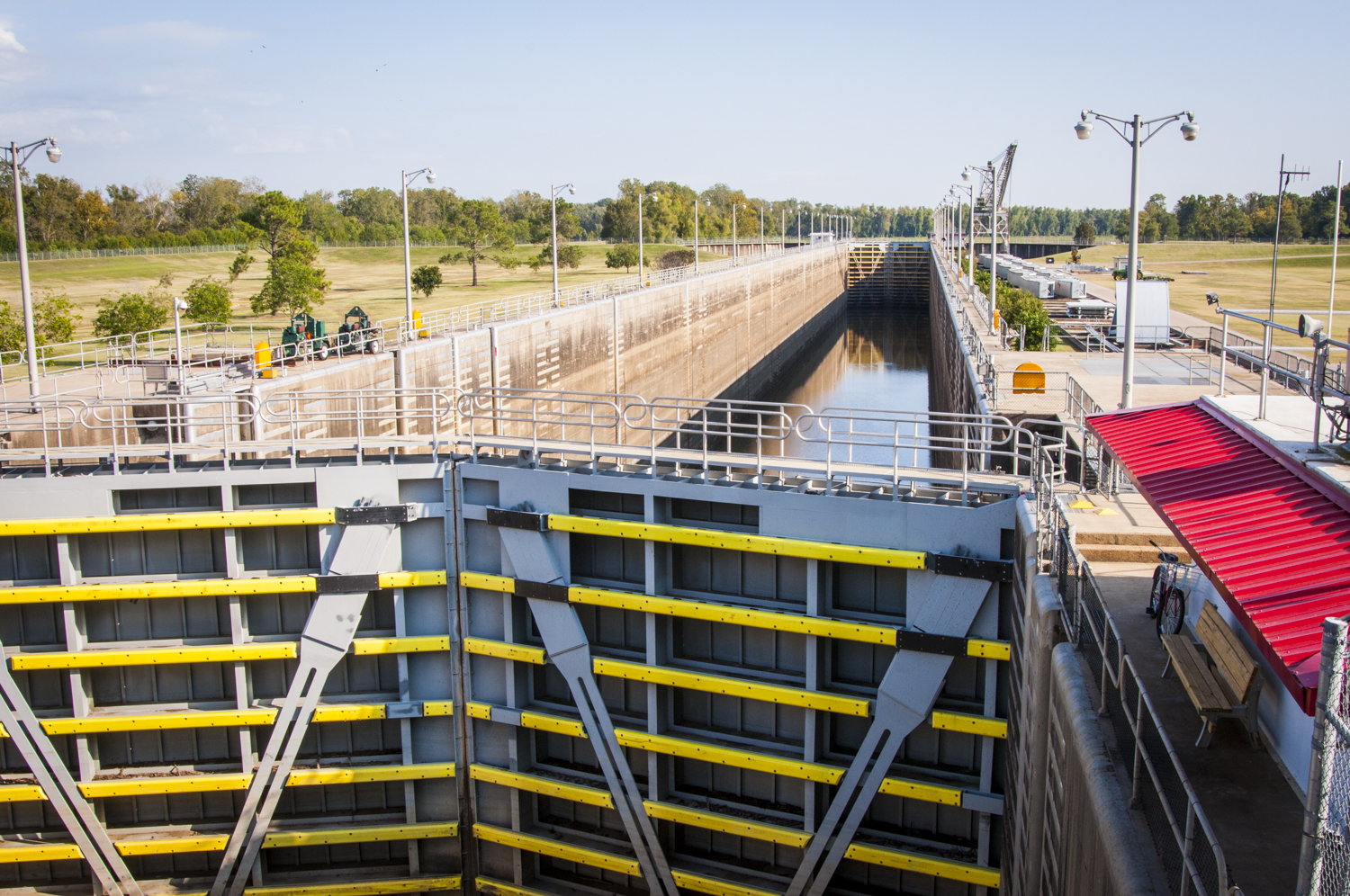
BRYAN PIAZZA Every day this happens. So it’s “pseudo-natural” because it’s held in this constant, but it’s also allowed to fluctuate. So looking at subsidence of the land, looking at sea-level rise, looking at human-induced changes in water flows, it may be that we need to manage the basin more naturally. But that may actually involve more management of the inputs from the Mississippi River, which again is counter-intuitive, you see, because what’s been sacrificed is not the high end, which periodically happens.
This is a phenomenon that you can see when you look at data on any dam. It isn’t the high end that is sacrificed. People look at a dam and they think, “Oh my God, we’re going to take away the high end.” What happens is you take away the low end, according to data below dams and below water-control structures. Researcher William Graft has looked at data all over the world on dams, and sees that this happens time and time again. We see it in the structures in our coastal zone here.
More water is coming through the control structure over time. Does that mean that there are changes in the amount of water coming down the Mississippi River? Maybe so. We have some data that suggests this may be the case. We also have some data that shows Louisiana is subsiding, and the Atchafalaya is subsiding in the lower part of the basin. It has to be, because the rest of the coast is.
What happens when you put more water in and the land goes down is that water can’t get out. So this drives our large-scale problems with water management because when you have a highly segmented system of levees along the river, that water comes down the river and gets held in.
At a certain level, the Atchafalaya River is like a bathtub, right? Because of the segmentation of that basin system between the swamps and the river, it takes water longer to go through the swamp. What may be happening is that sediment is beating the water out, due to what we call a hydraulic dam or a water dam, right? It would be like having a bathtub full of water and then trying to put water through it. If the water that you’re trying to put through it isn’t as high as the water in the bathtub, it won’t flow because water does not flow uphill. So we think that may be one of the large-scale water problems caused by the way we’re managing the structure, and by having held flow numbers static since 1950 or 1960 when the control structure was built.
We’re essentially using an old paradigm to manage a system that is 50 years old. Since it was built, there’s been a lot of subsidence, the sea level has increased, there’s been segmentation, and water moved. And we haven’t even discussed channel training of the water from the river, or the engineering that’s been done to try to get that water out of the basin as fast as possible. So you see, if the objective is to get the water through the river and out of the basin as fast as possible, you’ve got water racing down these routes and through the swamp. You see where that could be a large-scale problem. That is one problem.
Then enter in your canals, your levees and your smaller-scale features that are in some cases sending water in opposite directions than it’s supposed to flow, causing all this segmentation. You can see how that would be a problem. Then the water is kept in the swamp. Now if you keep water in a swamp for a long period of time, decomposition of leaves and things down in the water occurs underwater on the swamp floor. Bacteria and all these little bugs are eating these leaves, and what are they doing? Just like us, they’re respiring, right?
They’re taking in oxygen and putting out carbon dioxide. (In some cases they’re using other gases, but this is a good analogy.) So they’re taking oxygen out of the water. What happens when you drop the oxygen, drop the oxygen, drop the oxygen in a very shady environment? You get areas that have no oxygen. What happens when fish are in an area that has no oxygen? They can’t live there, right? So they move. So we have this lowering of oxygen that we call “hypoxia” – the same kind of hypoxia in the dead zone off Louisiana in the summer). It is the exact same process. We see it some summers for months at a time, depending upon how much water is in the basin.
So you see that the number one problem is water management.
NWNL Thank you so much for sharing your time and your knowledge of the Atchafalaya Basin system, as complicated as it is. Is there anything else you would like to add?
BRYAN PIAZZA I have thought long and hard about your questions and comments. This place is so complicated that you can’t easily wrap your head around it. I’ve realized that to find peace with it, there are two things to remember, because everything seems backwards in the Atchafalaya. Number One: Right now, it is what it is. Number Two: There’s no going backwards here.
Restoration in this system will not mean going backwards. Restoration here means going forward, envisioning what we want to see in the future as stakeholders who use and care about the Atchafalaya Basin. There’s a very long and very contentious history between stakeholders. The Nature Conservancy is trying to help with the visioning that needs to happen. But, meanwhile, I hope this helps you, because I have thought long, long, long and hard about this.
For your reference, Designing the Bayous, by Martin Reuss, is a very good book about the Atchafalaya Basin. He discusses McPhee. [“Atchafalaya: The Control of Nature,” by John McPhee. The New Yorker, Feb 23, 1987.] His book is fascinating; it is like the Rising Tide of the Atchafalaya. (cf, Rising Tide: The Great Mississippi Flood of 1927 and How it Changed America, by John M. Barry. New York: Simon and Shuster, 1997.)
Posted by NWNL on Aug. 28, 2014.
Transcription edited and condensed for clarity by Alison M. Jones, NWNL Director.
All images © Alison M. Jones. All rights reserved.