
The Largess of the Missisisippi
Mississippi River Basin
|
NEW ESRI StoryMaps: What's On Our Shelves & NWNL Song Library & No Water No Life ESRI |
Mississippi River Basin
Robert Birdsong
Historian and resident of the Lower Mississippi River Basin
Alison M Jones
NWNL Director & Photographer
Robert Birdsong grew up in Clarksdale Mississippi, hunting and exploring the banks and canebrakes lining the banks of the Mississippi River. Highly recommended to NWNL as a well-informed historian, he was a great NWNL interviewee – actually our 1st NWNL interviewee!
Robert started us off by giving us the opportunity to record his lifetime of insights into this NWNL case-study watershed. Documenting the Mississippi could consume many lifetimes. However, able to commit merely one lifetime, NWNL was fortunate to launch its quest with the insights of this well-versed historian and resident of the Lower Mississippi River Basin.

FROM PLANTATIONS to a PORT TOWN
MOUNDS, SLOUGHS and IRRIGATION
WATER CONTROLLED by LEVEES
LOCAL FLORA and FAUNA
SIGHTS on the MISSISSIPPI RIVER
BLACK MIGRATIONS to the DELTA [post-Civil War]
HUMAN ACTIVITY along the RIVERBANK
WILDLIFE in and along the RIVER
AGRICULTURE and CATFISH FARMING
CURRENT LEVEE CONDITIONS
INLAND DRAINAGE ISSUES
PUMPS & WETLANDS
MISSISSIPPI WEATHER
MISSISSIPPI RIVER’s FRESH WATER
CANEBRAKES & other RIVERINE FLORA
Key Quote The hunters and conservationists protecting the local quality of the soil and air and water qualities, don’t always get along with farmers. There seem to be different agendas for each or any of the groups. Farmers often use many chemicals; and we still have DDT in the soils. Those chemicals are dispersed into our shallow aquifers and can eventually contaminate the deeper aquifers here. – Robert Birdsong
All images © Alison M. Jones, unless otherwise noted. All rights reserved.
ALISON JONES Robert, thank you for your time and willingness to guide us from Clarksdale out to Friar’s Point, where we can watch the Mississippi River roll through Coahoma County. Let’s start with your introducing yourself.
ROBERT BIRDSONG I’m a 27-year veteran in the Clarksdale Fire Department and a local historian. My interest in the history of Clarksdale and Mississippi’s Coahoma County began at the age of three or four years old. Polly Clark, an elderly lady who lived across the street from my parent’s house, was a descendant of John Clark, founder of Clarksdale. She would tell me stories about the pioneers, Indians and settlers of Clarksdale and Coahoma County.
ALISON JONES As we head out of Clarksdale, please describe our route.
ROBERT BIRDSONG We are riding out of Oakhurst on Stovall Road. We’ll come back on Friar’s Point Road driving in between the headwaters to the Sunflower River [as it heads to the Mississippi River]. Southwest of here, the Stovall family established their plantation. In the center was the Clark Plantation. On the other side would be the King and Anderson Plantations, originally settled by the Dickerson brothers.
We are now headed about 20 miles out of Clarksdale to Friar’s Point, an early port city, established in 1830s and 1840s as river town on the Mississippi River in the northern part of Coahoma County.
ALISON JONES Is Friar’s Point a significant access point to the Mississippi?
ROBERT BIRDSONG It’s one Coahoma County’s direct access points to the Mississippi River. A landing and a boat ramp, now known as Montezuma Boat Ramp, is near the Montezuma Bar where a steamboat named the Montezuma sunk. Around the 1830’s – maybe even from 1812 – the sediment of the Mississippi River settled in around the wreckage forming a sand bar, depositing sand along banks of the Mississippi River.
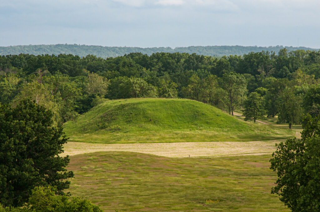
Now, we’re passing the “Indian Mound Subdivision” – and on your left is the Indian Mound for which it’s named. The Indian Mounds were used to provide higher land where the Indians could safely avoid flood waters of the Mississippi River.
Rains fill the numerous little sloughs, or swamps. Then that water flows into the Sunflower River. Clarksdale is the headwaters for the Sunflower River and its the Little Sunflower River is as far north as you can get with a boat. Travel by boat was only accessible in very high waters, or after some extreme rains. These little tributaries “finger out” into the northern part of Coahoma County.
Now you can see a pivot system that uses much less water than earlier approaches to crop irrigation. It is now a more preferred method since it doesn’t waste as much water as the “poly-pipe” form of irrigation. Its polypropylene pipe hooks up to a well and pump system that fills the pipe with water. They punch holes in those pipes to drain water into each furrow in between the crops. There tends to be much more runoff with poly pipes and thus much more water wasted – versus the pivot system that directs the water right to the crops.
ROBERT BIRDSONG Now we’re heading onto Highway One. Mississippi ‘s Highway One is known as The Great River Road, that runs north/south through the Mississippi Delta region, following the Mississippi River. Next, we’ll turn on another road into Friar’s Point to access the levee system.
Highway One was a historical marked trail that I believe the highway system marked several years ago at key “Points of Interest” along the highway with historical markers. Beyond this pivot system, is our first glimpse of the levee system. The Mississippi Levee System enters Mississippi at the Tennessee state line. There’s a marker where the levee takes off from the side of Highway 61 and travels south around Vicksburg.
North of Vicksburg you head into some rolling hills. The alluvial floodplain lies between Memphis and Vicksburg. The alluvial deposits of the Mississippi River flooded into the basin of what’s now the Yazoo Delta, which extends into Mississippi about 90 miles at its widest and a couple of hundred miles long. The reason this land is so flat is that soil was deposited when the river flooded and washed the soil smooth. As the river went back into its banks it left a little hill with a low-lying area. These rivers tended to flood first as waters came up. But in the event of catastrophe such as a levee breaking, as they did in 1927, it created a hole where a mountain of water rushed through. Like a dam breaking, it washed a hole hundreds of feet deep as the torrent flowed over the levee.
Now we’ve reached the levee system. We will ride on the top of the levee down a way. This cattle gap keeps cattle from crossing over from one plot of land to the other. Off to our left is a “spur levee.” This spur goes out where the currents come north. When water gets up high enough to get onto the levee , the spur directs the current back out into the channel to keep it from eating away at the side of the levee. Now when the water does get up on top of the levees, it will tend to have sand “boils” where there’s a small tributary up under the levee and the water starts boiling out. They will build sandbags around those “boils,” and let the water build up inside the boil until the pressure equalizes and the water stops seeping through. That also protects the levee system from that tributary of water undermining the strength of the levee.

ALISON JONES What wildlife do you find around here?
ROBERT BIRDSONG It’s very common to see deer and wild turkey. There’s one of my wives…oh, no, it’s a jackass. Ha, ha! Four mules — those are rare sights now. We don’t have a lot of mules around. It was with mules, dirt buckets and men that levees were built. They’d use a “borrow pit” where they’d borrow the dirt to build the levee – and then scoop it into a bucket. The mule would pull it back up to the top of the hill, dump the bucket and spread the dirt; and then go back down for another.
A guy named Charlie ran the levee camps and built most of the levees in the northern part of the Yazoo Delta. He became the subject of any blues songs. I believe it was Lowell Folson that had a song titled “Mr. Charlie’s Blues” – or something similar.
ALISON JONES What’s floating on the water, Robert?
ROBERT BIRDSONG Could be foam from boat engines. There’s a barge that looks like it’s gone up the river. Or it could be Styrofoam. Let’s walk down this way. I see a barge coming along. Wish we could get a steamship.
ALISON JONES Oh, wow. That’d be fun.
ROBERT BIRDSONG Of course, they’re not steam anymore but there’s still the paddle wheeler that the Queen Line uses. There are several of them on the river.
Water flowing through here is measured in thousands of cubic feet per second. During the Flood of 1927, south of about where the Arkansas River ties in, the cubic feet per second was said to be close to three million cubic feet per second.
Some of the big logs floating down the river are whole trees that are submerged under water. They are dangerous for small boats going up the river; but not so bad going down. There’s an eddy right here that has this log caught in that whirlpool; also called an eddy. Sometimes they get so fierce, they can just suck down a boat, logs and other stuff. Some of these logs are hundreds of years old; and this high water will often shake them loose. People will go out and get the log, pull it up close to the bank. When the river goes down, they can then put them on trailers and haul them out. They provide some beautiful wood once they dry out – even though they’ve been stuck on the bottom of the river for hundreds of years.
The current is really flowing. See how fast these logs are coming past? The river is not out of its banks; it’s against the banks. But usually there’s 100 yards of sandbar out there that you can walk on out. It drops off here about 10, 15, or 20 feet, and then once out onto the sandbar and beyond is the boat channel. Now, the barge is staying in the channel going upriver, even though it’s pretty deep out here. See how it flattens? The water smooths out right there and that’s where the sand bar is.
ALISON JONES Are there alligators down here?
ROBERT BIRDSONG The alligators are inland, not here. They are intentionally set out by Game and Fish to keep the beaver and snake populations down. Once in a while, there’ll be problems with an alligator that has grown accustomed to humans. In the Old River, out from Stovall, I think they had a couple there where people would throw fishing jigs at them to try to snag them. Of course, they cut their line before they haul them in. And what we’ve discovered is that the bottom is moving just as fast as the top. Sunsets out here are gorgeous. We’d come out here to hunt in the woods behind the levee here.
Most of this land is owned by huge lumber conglomerates from up north. They come in every 15-20 years to cut the lumber and haul it out. Then it’s rented to hunting clubs. Every once in a while, some hunting clubs have people with the funds to buy the land.
We’ve now moved on to Delta Landing on the Mississippi River, in the northern part of Coahoma County, north of Friar’s Point. We’re inside the levee system and on the banks of the Mississippi River. The river is high right now. Normally you could see a 100-yard sandbar off to my right, but with the spring floods still within the banks – not outside the banks yet – we’re right up on the banks of the Mississippi. It’s not uncommon for it to be another couple hundred yards, up against the base of the levee. At times it will get up to the top of the levee; and at that time, water is flowing approximately 2.5 million cubic feet per second through the Mississippi Channel.
ROBERT BIRDSONG There was a migration pattern change with the Flood of 1927. Prior to that, people moving into the Delta, primarily the black population, would come from the hills to work either in the farming or lumber industry to clear the land. After 1927, we saw a migration pattern from the southern part to the northern part of the Delta. Since the levee broke at Scott, they figured that levees in the northern part of the Delta were better constructed. Thus, it seemed safer for them and their families to move to the northern part of the Delta and continue their work there as farmers. As a historian of the local black community, I’ve noticed that migration pattern shows a mass population shift inside the levees. It may continue from the 1927 Flood.
ALISON JONES What was the life of a typical migrating family then? How would you describe their living conditions and their culture?
ROBERT BIRDSONG Well, in the earliest days after the Civil War, black families had the freedom to move around. One Carolina family’s history was that they heard that cotton in the Mississippi Delta grew big as trees. So, they said, “Cotton being our family industry, we wanted to see this cotton big as trees.” They came here and realized this cotton was just the same as it was in the Carolinas – but they stayed. There was always out-migration of blacks from the South and the Delta to the North. After the Civil War, a family in Livingston, Alabama, left to migrate into the Delta. As they headed to Coahoma County, the farmer’s slave said to the young son of this planter, “You know, your family’s been good to us, and we’d like to go with you. We don’t have anywhere to go.”
So, several slaves came with John — or Jack — Sherrod to Coahoma County, who promised them that as they cleared the land, a portion of it would be theirs. His family and several other black families made the trip and saw that farming and the land was good. One walked back to Livingston, Alabama; got his milk cows; and returned, making two trips walking to and from Livingston, Alabama. He committed himself to living in the Mississippi Delta, and his family farmed land that’s still in the family today. It was his share of the Sherrod farm.
Other black families farmed in the southern part of Coahoma County, creating a new African community. It was an area where timber was not available to build a railroad. So, they cut timber and shipped it out because low-lying areas and water obstacles restricted access to the railroad. This land was divvied up. The railroad company and a man named Isaiah Richardson formed the New Africa Land Development Corporation which sold 40-acre sections of land to black farmers, cleared their land and developed their community. That describes black migrations patterns through the Delta.

The Mississippi River, as it is now, is used by barge traffic and recreational use. Inside the levee system the land is predominately used for hunting. Hunting clubs still rent land from timber conglomerates that own most of the land throughout the Mississippi side of the river – and, I assume, on the Arkansas side also. But about every 15 to 20 years or so, they come through and selectively cut timber that’s grown inside the levee system. The Yazoo-Mississippi Levee Board is a part of the Army Corps of Engineers and is its own taxing entity for counties it serves and protects. The taxes they pay into the Levee Board maintain the levee system.
Hunting clubs inside the levee work with wildlife conservation groups to manage the game. On the Arkansas side, south of this point, there’s been a massive undertaking to rebuild the black bear population in the area. That has been so successful that the bear have started to cross over onto the Mississippi side. It’s now quite common for me to be sitting at a deer stand with my young son and see a black bear walk past It’s quite a wonderful experience to be out here before dawn with your children and watch the sun come up — experiencing the wildlife and the woods coming to life, whether you’re hunting or just experiencing this environment.
ALISON JONES What other species are here besides the bear?
ROBERT BIRDSONG There is a large population of white-tailed deer. Wild turkey is also very popular for hunters. Squirrels, rabbits, foxes, coyote and other predator animals are very prevalent — and sometimes quite a nuisance. There’s also wonderful fishing in the little “blue holes” that fill up in between the levee and the river. Probably some of them are “borrow pits” from the building of the levee when they scooped dirt out this hole to build the levee. When the river floods and then goes back within its banks, it leaves these “blue holes” and “borrow pits” full of water and fish from the river system. Many of the lakes on the inside were formed by cutoffs. When folks cut a channel to straighten out an S-curve in the river, it created lakes where the old channel had been. There are several of those are in Coahoma County and throughout the riversides up and down the Mississippi River.
ALISON JONES What fish are in the river? I hear there are gar [“Lepisosteidae”], left over from when an inlet from the Gulf of Mexico flowed up here. The photos I’ve seen show them as long, cylindrical fish with elongated, pointed jaws that resemble spears.
ROBERT BIRDSONG I think the gar is probably prehistoric in its origins. They eat a lot of the game fish; and thus, gar is very much a nuisance fish, as far as many fishermen are concerned. We now have German carp; and we are also experiencing some mussel or shellfish they brought down from the north to clean up the river. They are expanding into the area. They have been used to clean up the Great Lakes, but they’ve become a nuisance there. I think we’re starting to see some of that here.
We also fish for bream, or blue gill as it’s known in the hills over in the Appalachian Mountains. We call them bream or crappie; and we enjoy excellent crappie fishing. Of course there are several kinds of catfish. In the inland waterways we have the “mud cat” and the channel cat, and in the Mississippi River we have small-mouth and large-mouth bass. We also enjoy duck hunting, since this is a major flyway for ducks that travel south for the winter and back up north for the summer. You see, the Mississippi River is one of the major flyways for the waterfowl population of duck and geese.
ALISON JONES What about migratory songbirds?
ROBERT BIRDSONG Yes, yes! All the ducks and geese are migratory birds. The morning dove is also migratory. Their hunting seasons are regulated. The flyway is easy for ducks and geese to follow, as it follows the river – yet those migratory birds will expand 20, 30, 40 miles out from the main flyway.
ALISON JONES Your promotional poster says, “Agricultural Tours;” so let’s chat about the agriculture that occurs outside the levee. How have the levees allowed the cotton industry to thrive? And have the levees supported catfish farming, which I gather is also a huge industry here?
ROBERT BIRDSONG Well, when the settlers first settled here along the river in the 1830’s, they built their own levee system to protect their land. These were normally smaller levees, probably not any more than 3-4 feet tall. Later, they formed a Levee District and started building larger, more continuous levees. When a farmer built his own levee, there were usually breaks in the levee – but it did keep the strong current from washing his land away. Later, this Levee District was disbanded; and they then created the Army Corps of Engineers’ levee system, which I believe has been in existence since the 1870s or 1880s. [Google says 1885.]
Folks still farm a lot by the river, inside the levees [i.e., on the river side] – but usually those efforts are for short-term cropsm or serve as feed plots for deer or ducks. Primarily, their cash crops by the river and on some of the higher land on the islands in the river could have a farm of fairly significant size. But on the outside of the levee system [away from the river], levee protection is provided not only for the farmers, but also the general population – as was seen in the 1927 flood. With that historic flood, the levee broke north of Greenville, Mississippi at Scott and had a devastating effect on the animal and human populations.

ALISON JONES Tell us about the catfish farming out in the levee.
ROBERT BIRDSONG Catfish farming developed in the 1980s, I think. It kind of took off around Indianola, in the most central part of the Delta. In the northern part of the Delta there are several – primarily two – types of soil composition. The sandy loam soil is ideal for cotton since it’s a real loose soil and cotton has a long tap root that goes deep into the ground for water in the heat of the summer. And there’s a heavy clay soil that we call “buckshot,” or “gumbo soil.” That is more conducive to rice farming, as heavy clay will hold water and not let it just soak right through. I would think that in the catfish areas around Indianola there’s more of this heavy clay soil that holds the water – thus it doesn’t absorb into the soil quite so rapidly.
ALISON JONES So today, there are challenges to farming inside and outside the levee. What worries the population; or, what gives them confidence?
ROBERT BIRDSONG The levee system! We’re confident in our levee system. Now, what happens in the event of catastrophic disasters — an earthquake, perhaps? We are on the New Madrid earthquake fault line here in the northern Mississippi Delta – and thus susceptible to the dangers of an event similar to the 1811-12 New Madrid Quake that shook a swath of land so vast so that it rang bells in Boston. That’s quite a distance away! When those tectonic plates shifted, the history of the area claims that the Mississippi River ran backwards.
What we believe happened was that as those plates shifted and jumped over each other, they pushed water north – and pushed water south. Then water had to come back to fill that void – just as if you’d press water in the bathtub, it will have to fill back in. That’s what we believe happened – when the plates jumped, it looked like the water north of the plate jump was going north – flowing backwards. But also, as the water filled back south of the plate jump, it also appeared to flow backwards. As you can see in the river right here, the river has quite a current; so for it to turn and go the other way, short of a little eddy right on the edge, a shift back would take monumental energy.

ALISON JONES Let’s chat about the “Big Muddy’s” water quality and availability. I understand that the State of Mississippi has laws regulating those issues.
ROBERT BIRDSONG Along these inland waterways, farmers are in quite a battle with the U. S. Army Corp of Engineers’ interest in draining our inland water tributaries. Much of this issue goes back to FDR’s New Deal’s WPA/Works Progress Administration and CCC/Civilian Conservation Corps works. They did a lot of drainage work within the Mississippi-Yazoo Delta. The Sunflower River, for instance, was over-drained as a part of the CCC and WPA works; and the Tallahatchie system was under-drained. So, now the US Army Corps of Engineers is having to go back out and re-dredge the Tallahatchie River system. That has created some problems between soil-conservation people and the farmers who need to develop more farmland. Their fears are that the Corps might over-drain that system, as it did in the Sunflower River Basin, to address low-water levels. Pumps were installed in northern Coahoma County to add water into the Little Sunflower River – which runs through Clarksdale – to lift its water level a bit. Certainly, the Sunflower needs to be raised a few feet. I think they saw the mussel population had shifted a little farther north of Clarksdale, but to maintain their livable habitat they had to move downstream a bit.
ALISON JONES I’ve noticed the newspapers’ front-page stories on the pumps….
ROBERT BIRDSONG These are not the pumps north of Vicksburg that have been so much in the paper. These pumps are pumping water into the system. The pumps near Vicksburg were pumping water out of the system and over the levee into the Mississippi — water which would have drained much of the watershed that really needs that water. I believe those pumps are now on hold. The Pumps Project has been in the works for 40 or 50 years. We think that the EPA/Environmental Protection Agency has effectively just stopped that project.
ALISON JONES I understand that’s because of damage to the wetlands. Could you discuss those wetlands and how the pump affects the wetlands?
ROBERT BIRDSONG The pumps in Coahoma County that are pumping water into the Sunflower River will enhance the wetlands, But the pumps north of Vicksburg that they were going to use to drain the system would take water away from these wetlands. There are Department of Agriculture projects that farmers are using that lays aside land for wetlands. Frequently, they use that wetland area – that they’re creating out of their own farmland – for duck hunting. That has been very fruitful for farmers and hunters alike. I think it also appeases water and soil conservationists as well.
ALISON JONES Farmers, hunters and conservationists seem to form a complex triangle. How do those relationships work here? In every part of the world there are different dynamics to this classic triangle. So, could you describe those dynamics work here?
ROBERT BIRDSONG Well, the farmers depend on the soil for their living. The hunters and conservationists protecting the local quality of the soil and air and water qualities, don’t always get along with farmers. There seem to be different agendas for each or any of the groups. Farmers often use many chemicals and we still have DDT in the soils. Those chemicals are dispersed into our shallow aquifers and can eventually contaminate the deeper aquifers here.
ALISON JONES How do you describe your weather, the range of temperatures and various impacts?
ROBERT BIRDSONG Well, I don’t know if global warming is a factor, but we don’t see the snows we used to have. I don’t know if it’s due to a change in weather patterns, a natural phenomenon, or man-made impacts. It may be due to a natural phenomenon, or part of the earth’s cycle. In another couple hundred years, we could face another little Ice Age as part of a natural cycle.
But now winters are cold and summers are humid. It’s not a dry cold; it goes right through your clothes and into your bones. Especially out here on the river, the wind off that cold water is really cold, which is why I don’t duck hunt. I grew up swimming and fishing with my grandmother. I was a competitive swimmer and loved the water. But getting out there in the wintertime on the water is not for me. But it is for some — duck hunters are passionate about it.
ALISON JONES Back to the climate change issue, are there any concerns here in the Yazoo Delta about what could happen if Greenland sinks into the ocean due to global warming and water levels rise drastically?
ROBERT BIRDSONG No, I don’t think there is much concern. As for the concept of water levels rising with global warming, locally we are not too concerned. I think our highway system is 65’ above sea level; so, until the river rises 60 feet, we’re not going to worry about it. We’re not below sea level, as is New Orleans.
New Orleans was established on a natural levee system. As water would come up and go down in the natural flood stage, it deposited its own little natural berm so to speak. That’s where the French Quarter sits. The levees that broke in New Orleans during Hurricane Katrina were set on those old natural levee beds established by histories and centuries of flooding, sediment and local deposits. With today’s levee system, high water is not going to bother us. But – break the levee and we’ll be very worried.
ALISON JONES Let’s discuss your wetlands, a rich ecosystem in any watershed but with so many variations….
ROBERT BIRDSONG Here, you’ll run across our canebrakes while hunting–
ALISON JONES Yet I understand the canebrakes are almost all gone. I’ve been told about your dense, nearly impenetrable, tall thickets of bamboo-like, river cane (‘Arundinaria gigantea’) on the flood plains here. My understanding is they provided several critical services, including critical habitat for many bird, mammal, amphibian and reptile species. Additionally, they filtered runoff waters entering flowing streams. I’ve read Native Americans found many uses for the canes themselves – as tools, construction materials and more. It’s been called the “plastic” for Southeastern Native Americans. How do you assess today’s loss of canebrakes, due to their conversion to farmland? I hear it was a critical ecosystem for many species….
ROBERT BIRDSONG Well, farmers worked very hard to get rid of this stuff. See the doves take off as I shake it? This is the normal canebrake with this leafy, bamboo-like growth. There was also the real tall cane. It’s this cane that was used for fishing poles.
There are also little canes, which we call “spaghetti grass.” It furls up and can then come up 15, 20 feet away, as its root systems grow underground. These little “spaghetti-grass” canes” hold a lot of water but have no leaves. These two types of cane were prevalent throughout the Delta. Bear and deer lived in these canebrakes and could hide there very well. But for farmers, getting rid of the canebrakes presented a monumental task since it was so prevalent.
One friend started planting some ornamental cane in her yard. Her father-in-law came in and said, “No, hell no! As hard as I’ve worked to keep cane off this farm, here you are going to plant it in your yard!” That sums up the issue of the cane faced by the settlers. The cane thickets were so thick that you’d lose your bearing walking through the woods. You wouldn’t know which direction to go, or where you were when you came out of the canebrake.
But it’s great to have cane right next to your hunting stand, since you can be pretty sure the deer will come and bed down during the daytime. They feel safe in the canebrake. You can hear them rustling around in there and you just need to sit and wait for them to poke their head out. It’s quite thick and quite hard to walk through there. It’s not walking through a heavily wooded area where there’s little ground growth.
ALISON JONES Robert, thank you so much for this tour, and for sharing your wonderful local insights with this northerner! And don’t get lost in any canebrakes!
Posted by NWNL on October 20, 2026.
Transcription edited and condensed for clarity by Alison M. Jones.
All images © Alison M. Jones, unless otherwise noted. All rights reserved.